|
search place name
|
||
Ouled Ben Ali (Chlef, Algeria)Ouled Ben Ali is a town in the Chlef region of Algeria. An overview map of the region around Ouled Ben Ali is displayed below.
regional and 3d topo map of Ouled Ben Ali, Algeria ::

Ouled Ben Ali airports ::
The nearest airport is QAS - Ech-cheliff Ech Cheliff, located 22.4 km north west of Ouled Ben Ali.
Other airports nearby include TID - Tiaret Bou Chekif (77.2 km south), MUW - Ghriss (150.0 km south west), ALG - Algier Houari Boumediene (173.9 km north east), TAF - Oran Tafaraoui (187.8 km west), Nearby towns ::
El Mrazguïa (1.3km north west) //
Ouled ech Cheikh (1.5km south) //
El Karchouch (2.1km north) //
Ouled Hamou (2.3km east) //
Anceur el Bia (2.8km south west) //
Soulha (3.1km south) //
Chabat (3.3km north) //
Bou Lazzane (3.4km north) //
Douar el Azaïs (2.9km south west) //
Ouled Sidi Yahia (3.2km north east) //
Dehamnia (4.2km south) //
Douar ez Zourg (4.0km north east) //
Ouled Rehamnia (4.0km south west) //
Ouled Cheikh (4.4km north) //
Chenatra (4.2km south east) //
Kedjedjma (3.7km west) //
Oulad Sidi Aïssa (4.2km north east) //
Ouled el Agha (4.8km south west) //
El Bekalech (5.4km south west) //
El Khreia (6.0km north) //
Kouadjine (6.1km north) //
El Attatou (5.9km north east) //
Sendjas (5.4km north west) //
Douar el Hedjadj (5.4km west) //
Ouled Mouna (7.8km south west) //
Sidi el Hadj Hanni (7.2km west) //
Cheraïria (8.5km north west) //
Douar ed Douda (7.6km west) //
El Ouakda (8.5km north west) //
[all distances 'as the bird flies' and approximate] 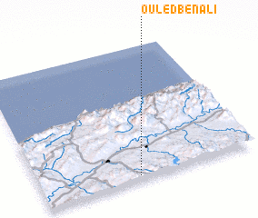 Places with similar names to Ouled Ben Ali, Algeria ::
// Oulad Ben Ali (MA)
// Oulad Ben Ali (MA)
// Oulad-Ben-Alioua (MA)
// Oulad Ben Ali (DZ)
// Oulad Ben Ali (DZ)
// Ouled Ben Ali (DZ)
// Ouled Benouali (DZ)
Disclaimer :: Information on this page comes without warranty of any kind |
||
|
Where is Ouled Ben Ali? Elevation and coordinates ::
Latitude (lat): 36°2'14"N Longitude (lon): 1°27'17"E
Elevation (approx.): 493m (map arrows pan, magnifying glasses zoom) |
||
|
Visiting Ouled Ben Ali? Hotel/Accommodation ::
Book a hotel in Ouled Ben Ali Travel Guide ::
Buy a travel guide for Algeria rental cars ::
car rental offers GPS waypoint ::
download a GPX waypoint (PoI) of Ouled Ben Ali for your GPS receiver
|
||