|
search place name
|
||
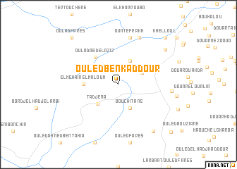
Ouled Ben Kaddour (Algeria)Ouled Ben Kaddour is a town in Algeria. An overview map of the region around Ouled Ben Kaddour is displayed below.
regional and 3d topo map of Ouled Ben Kaddour, Algeria ::
Ouled Ben Kaddour airports ::
The nearest airport is QAS - Ech-cheliff Ech Cheliff, located 21.3 km south east of Ouled Ben Kaddour.
Other airports nearby include TID - Tiaret Bou Chekif (115.1 km south), MUW - Ghriss (156.7 km south west), TAF - Oran Tafaraoui (177.6 km south west), ORN - Oran Es Senia (180.2 km south west), Nearby towns ::
El Mehadjer (4.0km north) //
Bou Chitane (4.0km south) //
Bou Douanou (3.5km north east) //
Tadjena (4.1km south west) //
El Mekaïn el Maloum (4.5km west) //
Oulad Abd el Aziz (5.2km north west) //
Oum Tefrakh (7.6km north) //
Abou el Hassen (7.9km north) //
Bouzghaïa (6.9km east) //
El Kebazelia (8.2km north east) //
El Morra (8.7km south east) //
Khelloul (9.5km north east) //
Oulad Fares (9.5km north west) //
Les Cinq Palmiers (10.1km south east) //
[all distances 'as the bird flies' and approximate] 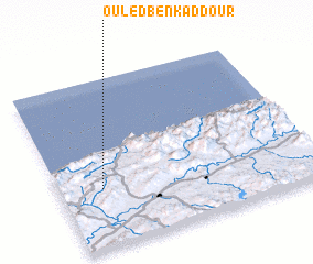 Places with similar names to Ouled Ben Kaddour, Algeria :: Disclaimer :: Information on this page comes without warranty of any kind |
||
|
Where is Ouled Ben Kaddour? Elevation and coordinates ::
Latitude (lat): 36°21'0"N Longitude (lon): 1°10'0"E
Elevation (approx.): 491m (map arrows pan, magnifying glasses zoom) |
||
|
Visiting Ouled Ben Kaddour? Hotel/Accommodation ::
Book a hotel in Ouled Ben Kaddour Travel Guide ::
Buy a travel guide for Algeria rental cars ::
car rental offers GPS waypoint ::
download a GPX waypoint (PoI) of Ouled Ben Kaddour for your GPS receiver
|
||