|
search place name
|
||
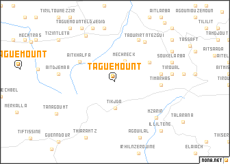
Taguemount (Tizi Ouzou, Algeria)Taguemount is a town in the Tizi Ouzou region of Algeria. An overview map of the region around Taguemount is displayed below.
regional and 3d topo map of Taguemount, Algeria ::
Taguemount airports ::
The nearest airport is ALG - Algier Houari Boumediene, located 85.1 km west of Taguemount.
Other airports nearby include BJA - Bejaja Soummam (87.5 km east), GJL - Jijel (159.4 km east), BSK - Biskra (237.7 km south east), Nearby towns ::
Mechreck (3.7km north) //
Tikjda (4.3km south) //
Aït Ouhalane (5.5km north east) //
Aït Khalfa (5.6km north west) //
Timarhas (6.1km east) //
Aït Bou Madhi (6.2km east) //
Tachat (7.5km north east) //
Taourirt-n-Tezgui (7.6km north east) //
Aït Berdjal (8.8km north) //
Ouadhia (8.5km north west) //
MʼZarir (8.0km south east) //
Aït Ahlal (9.2km north) //
Taguemount el Djedid (9.8km north west) //
Illiltene (10.0km south east) //
Aït Abid (10.5km north west) //
[all distances 'as the bird flies' and approximate]  Places with similar names to Taguemount, Algeria ::
// Tièkoumoundeu (BJ)
// Toukomindi (BJ)
// Diougouminata (ML)
// Tagmant (MA)
// Tucumandeua (BR)
// Taguemount (DZ)
// Taguemount (DZ)
// Taguemount (DZ)
// Taguemount (DZ)
// Taguemount (DZ)
Disclaimer :: Information on this page comes without warranty of any kind |
||
|
Where is Taguemount? Elevation and coordinates ::
Latitude (lat): 36°29'18"N Longitude (lon): 4°7'57"E
Elevation (approx.): 1065m (map arrows pan, magnifying glasses zoom) |
||
|
Visiting Taguemount? Hotel/Accommodation ::
Book a hotel in Taguemount Travel Guide ::
Buy a travel guide for Algeria rental cars ::
car rental offers GPS waypoint ::
download a GPX waypoint (PoI) of Taguemount for your GPS receiver
|
||