|
search place name
|
||
Torch (Algeria)Torch is a town in Algeria. An overview map of the region around Torch is displayed below.
regional and 3d topo map of Torch, Algeria ::

Torch airports ::
The nearest airport is ALG - Algier Houari Boumediene, located 42.2 km north of Torch.
Other airports nearby include QAS - Ech-cheliff Ech Cheliff (162.3 km west), BJA - Bejaja Soummam (178.9 km east), TID - Tiaret Bou Chekif (185.7 km south west), Nearby towns ::
Taourga (2.4km south west) //
Ouled Rabah (3.7km south) //
Sidi Bou Hamada (4.4km east) //
Bahata (5.6km north) //
El Khenag (4.8km west) //
Chorfa (4.8km east) //
Ouled Sidi Ahmar (6.0km west) //
Ouled Saïd (7.4km south) //
Goum Hadj Moussa (7.4km south east) //
Ramahma (7.6km north) //
Rhalem (6.5km east) //
Ahmed Ben Abdallah (8.0km south) //
Radjimi (7.5km north west) //
Goum Berredjouh (9.5km south east) //
[all distances 'as the bird flies' and approximate] 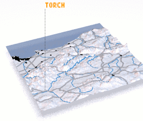 Places with similar names to Torch, Algeria ::
// Tercia (BO)
// Douar Aouaoucha (MA)
// Douar Chaouia (MA)
// Douar Chaouia (MA)
// Douar Chaouia (MA)
// Driouch (MA)
// Tarcha (RU)
// Trosh (RU)
// Trysh (RU)
// Turachi (RU)
Disclaimer :: Information on this page comes without warranty of any kind |
||
|
Where is Torch? Elevation and coordinates ::
Latitude (lat): 36°19'0"N Longitude (lon): 3°8'0"E
Elevation (approx.): 794m (map arrows pan, magnifying glasses zoom) |
||
|
Visiting Torch? Hotel/Accommodation ::
Book a hotel in Torch Travel Guide ::
Buy a travel guide for Algeria rental cars ::
car rental offers GPS waypoint ::
download a GPX waypoint (PoI) of Torch for your GPS receiver
|
||