|
search place name
|
||
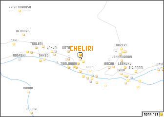
Cheliri (Abashis Raioni, Georgia)Cheliri is a town in the Abashis Raioni region of Georgia. An overview map of the region around Cheliri is displayed below.
regional and 3d topo map of Cheliri, Georgia ::
Cheliri airports ::
The nearest airport is MRV - Mineralnye Vody Mineralnyye Vody, located 137.8 km north of Cheliri.
Nearby towns ::
Barshi (0.4km south west) //
Kurashi (0.7km south) //
Iskari (1.3km south west) //
Lashkhreri (2.3km south west) //
Ugvali (2.3km south west) //
Ladreri (2.3km south west) //
Kalashi (2.9km south) //
Svipi (2.2km west) //
Zagari (2.3km west) //
Pkhutreri (2.3km west) //
Ebudi (3.1km south east) //
Katskhi (2.8km north west) //
P'ari (2.7km west) //
Tsalanari (3.1km south west) //
Lanteli (3.1km south west) //
Gvebaldi (4.1km south) //
Lamkheri (4.3km south east) //
Svip'i (4.6km south) //
Tviberi (4.9km south) //
Kartvani (4.7km south east) //
Lezgara (5.4km south) //
K'veda Luha (4.4km west) //
Chkidianari (4.5km east) //
Geshderi (4.7km west) //
Khozvrari (4.7km west) //
Becho (4.9km south east) //
Magardeli (6.1km south east) //
Chubari (5.2km west) //
Lakvri (5.2km west) //
[all distances 'as the bird flies' and approximate]  Places with similar names to Cheliri, Georgia ::
Disclaimer :: Information on this page comes without warranty of any kind |
||
|
Where is Cheliri? Elevation and coordinates ::
Latitude (lat): 43°3'7"N Longitude (lon): 42°31'41"E
Elevation (approx.): 1644m (map arrows pan, magnifying glasses zoom) |
||
|
Visiting Cheliri? Hotel/Accommodation ::
Book a hotel in Cheliri Travel Guide ::
Buy a travel guide for Georgia rental cars ::
car rental offers GPS waypoint ::
download a GPX waypoint (PoI) of Cheliri for your GPS receiver
|
||