|
search place name
|
||
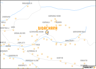
Didachara (Abashis Raioni, Georgia)Didachara is a town in the Abashis Raioni region of Georgia. An overview map of the region around Didachara is displayed below.
regional and 3d topo map of Didachara, Georgia ::
Didachara airports ::
The nearest airport is ERZ - Erzurum, located 214.7 km south west of Didachara.
Nearby towns ::
Tunadzeebi (1.8km north) //
Iremadzeebi (1.8km north) //
Geladzeebi (2.0km south) //
Godgadzeebi (2.1km south west) //
Pakʼsadzeebi (2.2km south east) //
Ghurta (2.2km south east) //
Satsʼikhuri (2.9km north east) //
Kurduli (3.6km north) //
Tsintskalashvilebi (3.6km north) //
Okʼruashvilebi (3.2km west) //
Dzirkvadzeebi (3.2km west) //
Gudasakho (3.6km north west) //
Uchʼkho (3.6km north west) //
Kortokhi (4.1km south east) //
Diakonidzeebi (3.7km south west) //
Vashakmadzeyebi (4.3km north east) //
Maniaketʼi (4.5km south east) //
Khulo (4.3km south west) //
Labaidzeyebi (5.6km north) //
Adadzeebi (5.4km north) //
Agara (4.9km north east) //
Vanadzeyebi (5.2km north east) //
Tabakhmela (5.3km south east) //
Dekanashvilebi (4.7km west) //
Stepanashvilebi (6.0km north east) //
Mekeidzeyebi (6.0km north east) //
Mekhelashvilebi (6.0km north east) //
Tʼago (5.8km south west) //
Okʼtomberi (5.6km south west) //
[all distances 'as the bird flies' and approximate]  Places with similar names to Didachara, Georgia ::
Disclaimer :: Information on this page comes without warranty of any kind |
||
|
Where is Didachara? Elevation and coordinates ::
Latitude (lat): 41°40'3"N Longitude (lon): 42°21'18"E
Elevation (approx.): 859m (map arrows pan, magnifying glasses zoom) |
||
|
Visiting Didachara? Hotel/Accommodation ::
Book a hotel in Didachara Travel Guide ::
Buy a travel guide for Georgia rental cars ::
car rental offers GPS waypoint ::
download a GPX waypoint (PoI) of Didachara for your GPS receiver
|
||