|
search place name
|
||
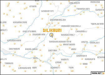
Dilikauri (Zestapʼonis Raioni, Georgia)Dilikauri is a town in the Zestapʼonis Raioni region of Georgia. An overview map of the region around Dilikauri is displayed below.
regional and 3d topo map of Dilikauri, Georgia ::
Nearby towns ::
Satsable (0.8km south east) //
Shrosha (3.5km south) //
Amsaisi (3.2km south east) //
Shrosha Verkhnyaya (3.4km south east) //
Sanakhshire (3.5km south west) //
Marjvena Rkvia (4.4km north) //
Zeda Sakʼara (3.5km west) //
Chala (4.6km south east) //
Martsʼkhena Rkvia (5.0km north) //
Beghlevi (5.2km north) //
Gamoghma Boslevi (5.2km north) //
Kʼveda Gezruli (4.0km east) //
Gaghma Boslevi (5.4km north) //
Shua Gezruli (4.2km east) //
Gantiadi (5.8km south) //
Zeda-Tsiplavake (5.5km south west) //
Kʼveda Tsipʼlavake (5.5km south west) //
Makatubani (5.7km south east) //
Dzirula (7.3km south) //
Verkhniye Gezruli (5.8km north east) //
Tseva Verkhnyaya (7.0km south west) //
Didtsipela (7.2km north) //
Patara-Gantiadi (8.2km south) //
Kveletubani (6.1km west) //
Dzhokoyeti (8.4km north) //
Pirveli Maisi (7.6km south west) //
Patara-Chkhirauli (7.0km north east) //
Kʼveda Tseva (8.8km south) //
Shorapani (8.3km south west) //
[all distances 'as the bird flies' and approximate] 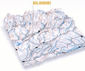 Places with similar names to Dilikauri, Georgia ::
Disclaimer :: Information on this page comes without warranty of any kind |
||
|
Where is Dilikauri? Elevation and coordinates ::
Latitude (lat): 42°9'24"N Longitude (lon): 43°10'23"E
Elevation (approx.): 567m (map arrows pan, magnifying glasses zoom) |
||
|
Visiting Dilikauri? Hotel/Accommodation ::
Book a hotel in Dilikauri Travel Guide ::
Buy a travel guide for Georgia rental cars ::
car rental offers GPS waypoint ::
download a GPX waypoint (PoI) of Dilikauri for your GPS receiver
|
||