|
search place name
|
||
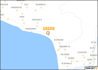
Gagra (Abashis Raioni, Georgia)Gagra is a town in the Abashis Raioni region of Georgia. An overview map of the region around Gagra is displayed below.
regional and 3d topo map of Gagra, Georgia ::
Gagra airports ::
The nearest airport is AER - Sochi, located 27.2 km north west of Gagra.
Other airports nearby include KRR - Krasnodar Pashkovskiy (208.7 km north west), STW - Stavropol Shpakovskoye (248.5 km north east), Nearby towns ::
Alpiiskoe (4.1km south east) //
Grebeshoki (4.8km north west) //
Orekhovo (5.7km north west) //
Otradnoye (6.0km south east) //
Otradnoe (6.3km south) //
Chigiripshi (5.0km west) //
Gagrapsta (7.1km south east) //
Kolkhida (9.7km south east) //
[all distances 'as the bird flies' and approximate] 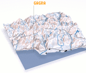 Places with similar names to Gagra, Georgia ::
Disclaimer :: Information on this page comes without warranty of any kind |
||
|
Where is Gagra? Elevation and coordinates ::
Latitude (lat): 43°19'20"N Longitude (lon): 40°14'37"E
Elevation (approx.): 220m (map arrows pan, magnifying glasses zoom) |
||
|
Visiting Gagra? Hotel/Accommodation ::
Book a hotel in Gagra Travel Guide ::
Buy a travel guide for Georgia rental cars ::
car rental offers GPS waypoint ::
download a GPX waypoint (PoI) of Gagra for your GPS receiver
|
||