|
search place name
|
||
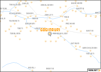
Goginauri (Abashis Raioni, Georgia)Goginauri is a town in the Abashis Raioni region of Georgia. An overview map of the region around Goginauri is displayed below.
regional and 3d topo map of Goginauri, Georgia ::
Goginauri airports ::
The nearest airport is ERZ - Erzurum, located 201.4 km south west of Goginauri.
Nearby towns ::
Karapeti (1.9km south) //
Jumushauri (2.3km south east) //
Matsqvaltʼa (2.3km south west) //
Oladauri (2.1km east) //
Paposhvilebi (2.8km east) //
Kviakhidzeebi (3.3km north west) //
Lomanauri (3.3km north west) //
Pʼurtio (4.6km north) //
Dzmagula (4.6km north east) //
Makhalakidzeebi (4.1km east) //
Dghvani (4.3km north west) //
Kedlebi (5.6km north) //
Butʼurauli (5.7km north) //
Qinchʼauri (5.0km east) //
Cheri (5.3km north east) //
Zamletʼi (6.9km north) //
Chʼao (6.6km north east) //
Kidzinidzeebi (5.8km west) //
Dabadzveli (6.9km north west) //
Nenia (6.9km north west) //
Ganakhleba (7.9km north) //
Pʼachʼkha (6.7km north east) //
Gundauri (6.7km north west) //
Tʼago (7.6km north east) //
Okʼtomberi (8.1km north east) //
Chʼanchʼkhalo (8.5km north west) //
Jabnidzeebi (7.4km north west) //
Khulo (9.6km north east) //
Skhepʼi (9.3km north west) //
[all distances 'as the bird flies' and approximate] 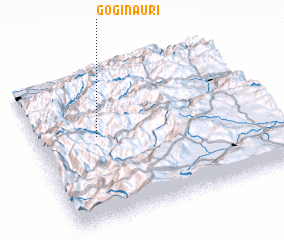 Places with similar names to Goginauri, Georgia ::
Disclaimer :: Information on this page comes without warranty of any kind |
||
|
Where is Goginauri? Elevation and coordinates ::
Latitude (lat): 41°34'0"N Longitude (lon): 42°16'0"E
Elevation (approx.): 1139m (map arrows pan, magnifying glasses zoom) |
||
|
Visiting Goginauri? Hotel/Accommodation ::
Book a hotel in Goginauri Travel Guide ::
Buy a travel guide for Georgia rental cars ::
car rental offers GPS waypoint ::
download a GPX waypoint (PoI) of Goginauri for your GPS receiver
|
||