|
search place name
|
||
Magi (Abashis Raioni, Georgia)Magi is a town in the Abashis Raioni region of Georgia. An overview map of the region around Magi is displayed below.
regional and 3d topo map of Magi, Georgia ::

Magi airports ::
The nearest airport is MRV - Mineralnye Vody Mineralnyye Vody, located 199.0 km north west of Magi.
Nearby towns ::
K'vemo Jomagha (2.3km south west) //
Vallikau (2.8km south west) //
Kakatikau (3.2km south west) //
Zemo Roka (4.2km east) //
Zemo-Jomagha (4.5km south west) //
Elontkau (5.4km south east) //
Puriat (6.1km north east) //
K'vemo Roka (5.7km south east) //
Zakka (6.4km north east) //
Kesatikau (7.6km north east) //
Bagiata (8.8km south) //
Saubyn (8.6km north) //
Zekmikau (8.1km north east) //
Tsagatikau (7.6km south east) //
Regakh (8.9km north) //
Gazat (9.0km north) //
Zrigata (8.7km north east) //
[all distances 'as the bird flies' and approximate] 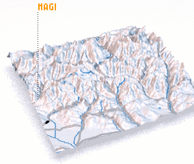 Places with similar names to Magi, Georgia ::
Disclaimer :: Information on this page comes without warranty of any kind |
||
|
Where is Magi? Elevation and coordinates ::
Latitude (lat): 42°35'10"N Longitude (lon): 44°4'20"E
Elevation (approx.): 2099m (map arrows pan, magnifying glasses zoom) |
||
|
Visiting Magi? Hotel/Accommodation ::
Book a hotel in Magi Travel Guide ::
Buy a travel guide for Georgia rental cars ::
car rental offers GPS waypoint ::
download a GPX waypoint (PoI) of Magi for your GPS receiver
|
||