|
search place name
|
||
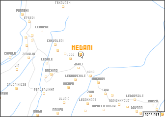
Medani (Georgia)Medani is a town in Georgia. An overview map of the region around Medani is displayed below.
regional and 3d topo map of Medani, Georgia ::
Medani airports ::
The nearest airport is MRV - Mineralnye Vody Mineralnyye Vody, located 187.7 km north east of Medani.
Nearby towns ::
Jgali (2.3km south) //
Lara (2.0km west) //
Kukheshi (3.1km west) //
Koko (4.2km south) //
Lekharch'ile (5.0km south) //
Naguru (4.6km north west) //
Mukhuri (6.2km south east) //
Ch'k'valeri (5.6km north west) //
Mik'ava (7.0km south) //
Sach'ino (6.4km south west) //
Lesale (6.0km west) //
Zumi (8.7km south) //
Mazandara (7.4km south west) //
T'aia (8.9km south east) //
Meore-Taia (9.8km south east) //
Tsalenjikha (10.3km south west) //
[all distances 'as the bird flies' and approximate]  Places with similar names to Medani, Georgia ::
Disclaimer :: Information on this page comes without warranty of any kind |
||
|
Where is Medani? Elevation and coordinates ::
Latitude (lat): 42°40'34"N Longitude (lon): 42°9'22"E
Elevation (approx.): 432m (map arrows pan, magnifying glasses zoom) |
||
|
Visiting Medani? Hotel/Accommodation ::
Book a hotel in Medani Travel Guide ::
Buy a travel guide for Georgia rental cars ::
car rental offers GPS waypoint ::
download a GPX waypoint (PoI) of Medani for your GPS receiver
|
||