|
search place name
|
||
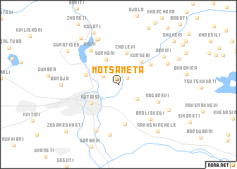
Motsameta (Georgia)Motsameta is a town in Georgia. An overview map of the region around Motsameta is displayed below.
regional and 3d topo map of Motsameta, Georgia ::
Motsameta airports ::
The nearest airport is MRV - Mineralnye Vody Mineralnyye Vody, located 216.8 km north of Motsameta.
Nearby towns ::
Gelat'i (1.5km north east) //
Noga (2.2km north west) //
Godogani (3.1km south east) //
Sormoni (4.2km north) //
Kursebi (4.5km north east) //
Kʼutʼaisi (4.3km south west) //
Cholevi (5.1km north) //
Dzhimastaro (4.2km west) //
Naboslevi (4.9km north east) //
Chognari (6.2km south) //
Nagarevi (5.3km south east) //
Rioni (6.4km north west) //
Broliskedi (6.6km south east) //
Zarat'i (7.6km north) //
Mechkheri (7.6km north) //
Odilauri (7.7km south) //
Kvakhchiri (8.0km south) //
Koka (6.6km north east) //
Orpiri (6.9km north east) //
Chalast'avi (7.0km south east) //
Kudoti (8.7km north) //
Op'urch'khet'i (8.6km north west) //
Nakhshirghele (8.6km south east) //
Gumatiges (8.0km north west) //
Shukeri (9.4km north east) //
Zeda Meskhet'i (9.6km south west) //
[all distances 'as the bird flies' and approximate]  Places with similar names to Motsameta, Georgia ::
// Meadow Summit (US)
// Moutsamoudou (KM)
// Mtsamdou (KM)
// Matsumoto (JP)
// Matsumoto (JP)
// Mitsumata (JP)
// Mitsumata (JP)
Disclaimer :: Information on this page comes without warranty of any kind |
||
|
Where is Motsameta? Elevation and coordinates ::
Latitude (lat): 42°17'17"N Longitude (lon): 42°45'19"E
Elevation (approx.): 261m (map arrows pan, magnifying glasses zoom) |
||
|
Visiting Motsameta? Hotel/Accommodation ::
Book a hotel in Motsameta Travel Guide ::
Buy a travel guide for Georgia rental cars ::
car rental offers GPS waypoint ::
download a GPX waypoint (PoI) of Motsameta for your GPS receiver
|
||