|
search place name
|
||
Sviri (Abashis Raioni, Georgia)Sviri is a town in the Abashis Raioni region of Georgia. An overview map of the region around Sviri is displayed below.
regional and 3d topo map of Sviri, Georgia ::
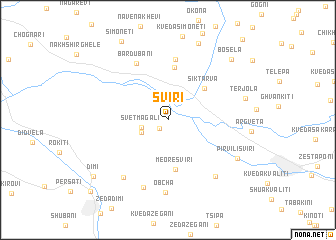
Nearby towns ::
Rodinauli (1.2km south west) //
Svetmagali (2.3km west) //
Ts'khent'aro (2.6km south west) //
Sik't'arva (4.6km north east) //
Meore Sviri (5.6km south) //
Etseri (5.9km north) //
Akhalubani (6.8km north) //
Bardubani (6.8km north) //
Meore Obch'a (7.8km south) //
Obcha (8.1km south) //
Pirveli Obch'a (7.4km south west) //
Akhali Sviri (7.4km south east) //
Pirvili Sviri (7.2km south east) //
Tʼerjola (6.8km east) //
Chkharetseri (8.9km north) //
Bosela (8.5km north east) //
Simonet'i (9.5km north west) //
Dimi (8.8km south west) //
Bagdatʼi (10.2km south west) //
[all distances 'as the bird flies' and approximate] 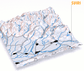 Places with similar names to Sviri, Georgia ::
Disclaimer :: Information on this page comes without warranty of any kind |
||
|
Where is Sviri? Elevation and coordinates ::
Latitude (lat): 42°9'23"N Longitude (lon): 42°54'9"E
Elevation (approx.): 133m (map arrows pan, magnifying glasses zoom) |
||
|
Visiting Sviri? Hotel/Accommodation ::
Book a hotel in Sviri Travel Guide ::
Buy a travel guide for Georgia rental cars ::
car rental offers GPS waypoint ::
download a GPX waypoint (PoI) of Sviri for your GPS receiver
|
||