|
search place name
|
||
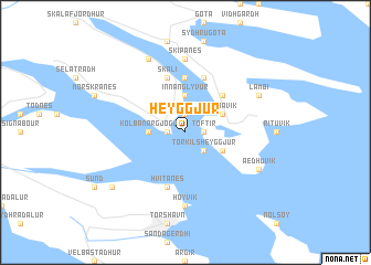
Heyggjur (Færøerne, Faroe Islands)Heyggjur is a town in the Færøerne region of Faroe Islands. An overview map of the region around Heyggjur is displayed below.
regional and 3d topo map of Heyggjur, Faroe Islands ::
Heyggjur airports ::
The nearest airport is FAE - Vagar, located 27.8 km west of Heyggjur.
Nearby towns ::
Saltnes (0.9km east) //
Gerðar (0.9km west) //
Toftir (0.9km east) //
Sevlendi (1.9km north) //
Við Sjógv (1.9km north) //
Strendur (1.9km north) //
Torkilsheyggjur (2.0km south east) //
Innan Glyvur (3.7km north) //
Kolbanargjógv (1.7km west) //
Saltangará (2.5km north east) //
Runavík (2.5km north east) //
Nes (2.5km south east) //
Glyvrar (4.1km north east) //
Lambareiði (4.1km north east) //
Ytri Skáli (5.6km north) //
Grógv (5.6km north) //
Søldarfjørður (5.6km north) //
Skáli (5.6km north) //
Hvítanes (5.6km south) //
Hoyvík (7.4km south) //
Skipanes (7.4km north) //
Lambi (5.1km north east) //
Langasandur (7.6km north) //
Æðuvík (5.1km south east) //
Kaldbak (6.6km south west) //
[all distances 'as the bird flies' and approximate] 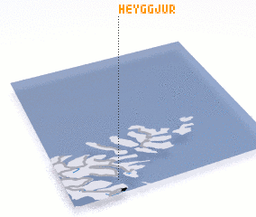
Disclaimer :: Information on this page comes without warranty of any kind |
||
|
Where is Heyggjur? Elevation and coordinates ::
Latitude (lat): 62°6'0"N Longitude (lon): 6°45'0"W
(map arrows pan, magnifying glasses zoom) |
||
|
Visiting Heyggjur? Hotel/Accommodation ::
Book a hotel in Heyggjur Travel Guide ::
rental cars ::
car rental offers GPS waypoint ::
download a GPX waypoint (PoI) of Heyggjur for your GPS receiver
|
||