|
search place name
|
||
Beija-Flor (Piauí, Brazil)Beija-Flor is a town in the Piauí region of Brazil. An overview map of the region around Beija-Flor is displayed below.
regional and 3d topo map of Beija-Flor, Brazil ::

Beija-Flor airports ::
The nearest airport is THE - Teresina Senador Petronio Portella, located 157.3 km south west of Beija-Flor.
Other airports nearby include SLZ - Sao Luis Marechal Cunha Machado Intl (255.1 km north west), Nearby towns ::
Cacimbão (1.4km north west) //
Sambaíba (1.5km north east) //
Baixão do Chiqueiro (1.5km west) //
Vargem de Cima (2.2km south east) //
São João (3.3km east) //
Minadouro (3.4km south west) //
Vargem de Baixo (4.1km south east) //
Talhado (4.2km north) //
Açude Velho (4.5km north) //
Tabuleiro de Dentro (4.6km north west) //
Vereda Nova (4.8km north east) //
Morro do Chapéu (5.0km west) //
Milagres (5.2km south west) //
Aroeira (5.6km north) //
Bonfim (6.4km south east) //
Barreiro (7.0km south) //
Barreiro (7.1km north) //
Tapera (7.2km south east) //
Mirante (8.2km south west) //
Pereiras (8.5km south) //
Campestre (8.6km south west) //
Boa Vista (8.7km north west) //
Alegria (8.8km south) //
Pedro Rodrigues (8.9km north) //
Sítio Alegre (9.1km east) //
Cabo Verde (10.5km south west) //
[all distances 'as the bird flies' and approximate] 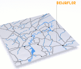 Places with similar names to Beija-Flor, Brazil ::
Disclaimer :: Information on this page comes without warranty of any kind |
||
|
Where is Beija-Flor? Elevation and coordinates ::
Latitude (lat): 3°45'22"S Longitude (lon): 42°15'23"W
Elevation (approx.): 112m (map arrows pan, magnifying glasses zoom) |
||
|
Visiting Beija-Flor? Hotel/Accommodation ::
Book a hotel in Beija-Flor Travel Guide ::
Buy a travel guide for Brazil rental cars ::
car rental offers GPS waypoint ::
download a GPX waypoint (PoI) of Beija-Flor for your GPS receiver
|
||