|
search place name
|
||
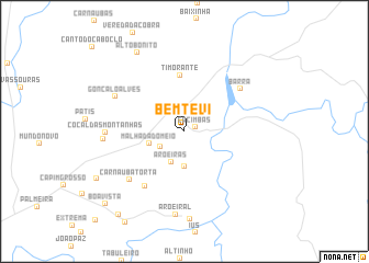
Bem-Te-Vi (Piauí, Brazil)Bem-Te-Vi is a town in the Piauí region of Brazil. An overview map of the region around Bem-Te-Vi is displayed below.
regional and 3d topo map of Bem-Te-Vi, Brazil ::
Bem-Te-Vi airports ::
The nearest airport is THE - Teresina Senador Petronio Portella, located 166.6 km south west of Bem-Te-Vi.
Nearby towns ::
Cacimbas (1.2km east) //
São Geraldo (2.9km south west) //
Aroeiras (3.4km south west) //
Porto dos Tinguis (3.6km south) //
Malhada do Meio (3.8km west) //
Timorante (5.8km north) //
Boqueirão (6.9km south west) //
Barra (7.1km north east) //
Carnaúba Torta (7.5km south west) //
Gonçalo Alves (7.9km north west) //
Cocal das Montanhas (8.0km west) //
Chapada de São Miguel (8.3km west) //
Aroeiral (8.5km south) //
Alto Bonito (9.3km north west) //
Olho-dʼÁgua das Palmeiras (10.1km south west) //
Ingazeira (10.8km south west) //
Boa Vista (10.9km south west) //
[all distances 'as the bird flies' and approximate] 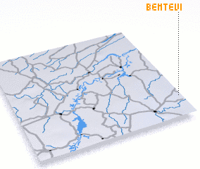 Places with similar names to Bem-Te-Vi, Brazil ::
Disclaimer :: Information on this page comes without warranty of any kind |
||
|
Where is Bem-Te-Vi? Elevation and coordinates ::
Latitude (lat): 3°47'20"S Longitude (lon): 42°1'4"W
Elevation (approx.): 38m (map arrows pan, magnifying glasses zoom) |
||
|
Visiting Bem-Te-Vi? Hotel/Accommodation ::
Book a hotel in Bem-Te-Vi Travel Guide ::
Buy a travel guide for Brazil rental cars ::
car rental offers GPS waypoint ::
download a GPX waypoint (PoI) of Bem-Te-Vi for your GPS receiver
|
||