|
search place name
|
||
Bom Jesus do Norte (Espírito Santo, Brazil)Bom Jesus do Norte is a town in the Espírito Santo region of Brazil. An overview map of the region around Bom Jesus do Norte is displayed below.
regional and 3d topo map of Bom Jesus do Norte, Brazil ::

Bom Jesus do Norte airports ::
The nearest airport is CAW - Campos Bartolomeu Lisandro, located 74.7 km south east of Bom Jesus do Norte.
Other airports nearby include VIX - Vitoria Goiabeiras (172.4 km north east), JDF - Juiz De Fora Francisco De Assis (193.3 km south west), IPN - Ipatinga Usiminas (201.4 km north west), GIG - Rio De Janeiro Galeao Antonio Carlos Jobim (248.3 km south west), Nearby towns ::
Bom Jesus do Itabapoana (2.5km south west) //
Soledade (5.1km south west) //
Plínio Silveira (5.6km south) //
Barra (6.9km west) //
Antônio Mariano (8.2km south east) //
Iuru (7.8km south east) //
Benedito dos Santos (8.9km north west) //
Juca Azevêdo (8.9km south west) //
Bom Jardim (8.9km north east) //
Boa Fortuna (10.1km north west) //
[all distances 'as the bird flies' and approximate] 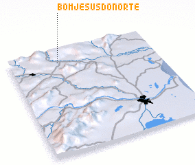 Places with similar names to Bom Jesus do Norte, Brazil :: Disclaimer :: Information on this page comes without warranty of any kind |
||
|
Where is Bom Jesus do Norte? Elevation and coordinates ::
Latitude (lat): 21°7'0"S Longitude (lon): 41°40'0"W
Elevation (approx.): 96m (map arrows pan, magnifying glasses zoom) |
||
|
Visiting Bom Jesus do Norte? Hotel/Accommodation ::
Book a hotel in Bom Jesus do Norte Travel Guide ::
Buy a travel guide for Brazil rental cars ::
car rental offers GPS waypoint ::
download a GPX waypoint (PoI) of Bom Jesus do Norte for your GPS receiver
|
||