|
search place name
|
||
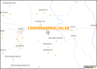
Campina do Paiol Velho (Parana, Brazil)Campina do Paiol Velho is a town in the Parana region of Brazil. An overview map of the region around Campina do Paiol Velho is displayed below.
regional and 3d topo map of Campina do Paiol Velho, Brazil ::
Campina do Paiol Velho airports ::
The nearest airport is BFH - Curitiba Bacacheri, located 133.4 km east of Campina do Paiol Velho.
Other airports nearby include CWB - Curitiba Afonso Pena (138.8 km east), JOI - Joinville Lauro Carneiro De Loyola (194.3 km south east), NVT - Navegantes Ministro Victor Konder Intl (245.1 km south east), Nearby towns ::
Queimadinhas (2.4km north) //
Balão Primeiro (3.7km south east) //
Colônia São Lourenço (4.5km south west) //
Estação Experimental (4.6km north west) //
Assungui (4.8km south) //
Florestal (4.8km north west) //
Manducas (7.1km south) //
Fernandes Pinheiro (7.6km north) //
Bituva dos Lopes (8.3km south) //
Agrovila (8.6km north) //
Boa Vista (8.2km east) //
Coxinhos (8.9km north west) //
[all distances 'as the bird flies' and approximate]  Places with similar names to Campina do Paiol Velho, Brazil :: Disclaimer :: Information on this page comes without warranty of any kind |
||
|
Where is Campina do Paiol Velho? Elevation and coordinates ::
Latitude (lat): 25°29'8"S Longitude (lon): 50°33'20"W
Elevation (approx.): 830m (map arrows pan, magnifying glasses zoom) |
||
|
Visiting Campina do Paiol Velho? Hotel/Accommodation ::
Book a hotel in Campina do Paiol Velho Travel Guide ::
Buy a travel guide for Brazil rental cars ::
car rental offers GPS waypoint ::
download a GPX waypoint (PoI) of Campina do Paiol Velho for your GPS receiver
|
||