|
search place name
|
||
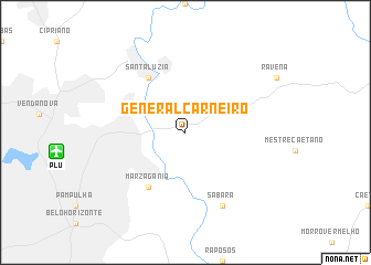
General Carneiro (Minas Gerais, Brazil)General Carneiro is a town in the Minas Gerais region of Brazil. An overview map of the region around General Carneiro is displayed below.
regional and 3d topo map of General Carneiro, Brazil ::
General Carneiro airports ::
The nearest airport is PLU - Belo Horizonte Pampulha Carlos Drummond De Andrade, located 12.4 km west of General Carneiro.
Other airports nearby include CNF - Belo Horizonte Tancredo Neves Intl (26.3 km north west), IPN - Ipatinga Usiminas (146.7 km east), JDF - Juiz De Fora Francisco De Assis (221.7 km south), VAG - Varginha Major Brigadeiro Trompowsky (258.9 km south west), Nearby towns ::
Marzagânia (6.6km south west) //
Santa Luzia (6.6km north west) //
Sabará (8.2km south east) //
[all distances 'as the bird flies' and approximate] 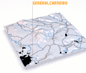 Places with similar names to General Carneiro, Brazil ::
// General Carneiro (BR)
// General Carneiro (BR)
Disclaimer :: Information on this page comes without warranty of any kind |
||
|
Where is General Carneiro? Elevation and coordinates ::
Latitude (lat): 19°50'0"S Longitude (lon): 43°50'0"W
Elevation (approx.): 886m (map arrows pan, magnifying glasses zoom) |
||
|
Visiting General Carneiro? Hotel/Accommodation ::
Book a hotel in General Carneiro Travel Guide ::
Buy a travel guide for Brazil rental cars ::
car rental offers GPS waypoint ::
download a GPX waypoint (PoI) of General Carneiro for your GPS receiver
|
||