|
search place name
|
||
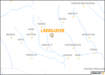
Laranjeira (Mato Grosso, Brazil)Laranjeira is a town in the Mato Grosso region of Brazil. An overview map of the region around Laranjeira is displayed below.
regional and 3d topo map of Laranjeira, Brazil ::
Laranjeira airports ::
The nearest airport is CGB - Cuiaba Marechal Rondon, located 66.6 km north east of Laranjeira.
Nearby towns ::
João Leite (4.1km south west) //
Aranha (5.1km north west) //
Alegre (6.6km north east) //
Porteira (7.1km west) //
Lagoa (7.4km west) //
Fazenda de Cima (8.0km south east) //
Lavrinha (9.1km south east) //
Boa Vista (10.3km north east) //
Forquilha (10.3km south west) //
[all distances 'as the bird flies' and approximate] 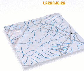 Places with similar names to Laranjeira, Brazil ::
// Laranjeira (PT)
// Laranjeira (PT)
// Laranjeira (PT)
// Laranjeira (PT)
// Laranjeira (PT)
// Laranjeira (PT)
// Laranjeiro (PT)
// Laranjeiro (PT)
// Loranger (US)
// LʼOrangerie (DZ)
Disclaimer :: Information on this page comes without warranty of any kind |
||
|
Where is Laranjeira? Elevation and coordinates ::
Latitude (lat): 15°54'0"S Longitude (lon): 56°41'0"W
Elevation (approx.): 202m (map arrows pan, magnifying glasses zoom) |
||
|
Visiting Laranjeira? Hotel/Accommodation ::
Book a hotel in Laranjeira Travel Guide ::
Buy a travel guide for Brazil rental cars ::
car rental offers GPS waypoint ::
download a GPX waypoint (PoI) of Laranjeira for your GPS receiver
|
||