|
search place name
|
||
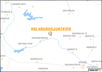
Malhada do Juàzeiro (Rio Grande do Norte, Brazil)Malhada do Juàzeiro is a town in the Rio Grande do Norte region of Brazil. An overview map of the region around Malhada do Juàzeiro is displayed below.
regional and 3d topo map of Malhada do Juàzeiro, Brazil ::
Malhada do Juàzeiro airports ::
The nearest airport is NAT - Natal Augusto Severo, located 166.1 km east of Malhada do Juàzeiro.
Other airports nearby include CPV - Campina Grande Presidente Joao Suassuna (208.4 km south east), JPA - Joao Pessoa Presidente Castro Pinto (261.3 km south east), FOR - Fortaleza Pinto Martins Intl (283.3 km north west), Nearby towns ::
Pedras Brancas (4.3km south west) //
Bonsucesso (7.0km east) //
São Bento (10.1km south east) //
Santa Maria (10.7km north east) //
[all distances 'as the bird flies' and approximate] 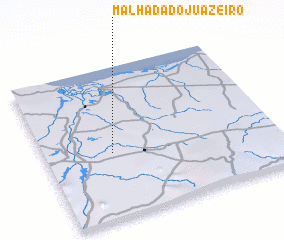 Places with similar names to Malhada do Juàzeiro, Brazil :: Disclaimer :: Information on this page comes without warranty of any kind |
||
|
Where is Malhada do Juàzeiro? Elevation and coordinates ::
Latitude (lat): 5°34'8"S Longitude (lon): 36°42'28"W
Elevation (approx.): 66m (map arrows pan, magnifying glasses zoom) |
||
|
Visiting Malhada do Juàzeiro? Hotel/Accommodation ::
Book a hotel in Malhada do Juàzeiro Travel Guide ::
Buy a travel guide for Brazil rental cars ::
car rental offers GPS waypoint ::
download a GPX waypoint (PoI) of Malhada do Juàzeiro for your GPS receiver
|
||