|
search place name
|
||
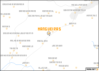
Mangueiras (Rio de Janeiro, Brazil)Mangueiras is a town in the Rio de Janeiro region of Brazil. An overview map of the region around Mangueiras is displayed below.
regional and 3d topo map of Mangueiras, Brazil ::
Mangueiras airports ::
The nearest airport is STU - Rio De Janeiro Santa Cruz, located 44.8 km south of Mangueiras.
Other airports nearby include GIG - Rio De Janeiro Galeao Antonio Carlos Jobim (44.9 km south east), SDU - Rio De Janeiro Santos Dumont (58.5 km south east), JDF - Juiz De Fora Francisco De Assis (86.2 km north), VAG - Varginha Major Brigadeiro Trompowsky (222.5 km north west), Nearby towns ::
Conrado (1.9km north east) //
Paes Leme (3.7km south west) //
Jaceruba (5.4km south east) //
Sacra Família do Tinguá (7.3km north west) //
Arcádia (7.0km north east) //
Morro Azul (8.4km north) //
Monsores (9.1km north) //
Cilândia (9.3km north) //
Bonfim (8.8km north east) //
Mário Belo (9.0km south west) //
Barão do Amparo (11.3km north west) //
[all distances 'as the bird flies' and approximate]  Places with similar names to Mangueiras, Brazil ::
// Mancruz (PH)
// Mancruz (PH)
// Mangoeiros (PT)
// Mangoeiros (PT)
// Mangurići (BA)
// Mankres (RU)
// Monkres (RU)
// Moŭng Rœssei (KH)
// Menggeris (ID)
// Menggeris (ID)
Disclaimer :: Information on this page comes without warranty of any kind |
||
|
Where is Mangueiras? Elevation and coordinates ::
Latitude (lat): 22°32'57"S Longitude (lon): 43°34'43"W
Elevation (approx.): 178m (map arrows pan, magnifying glasses zoom) |
||
|
Visiting Mangueiras? Hotel/Accommodation ::
Book a hotel in Mangueiras Travel Guide ::
Buy a travel guide for Brazil rental cars ::
car rental offers GPS waypoint ::
download a GPX waypoint (PoI) of Mangueiras for your GPS receiver
|
||