|
search place name
|
||
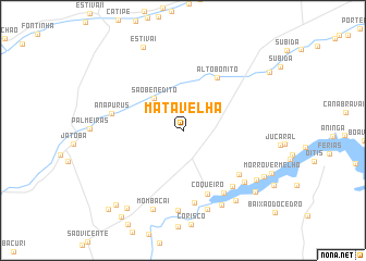
Mata Velha (Maranhão, Brazil)Mata Velha is a town in the Maranhão region of Brazil. An overview map of the region around Mata Velha is displayed below.
regional and 3d topo map of Mata Velha, Brazil ::
Mata Velha airports ::
The nearest airport is THE - Teresina Senador Petronio Portella, located 210.2 km south of Mata Velha.
Other airports nearby include SLZ - Sao Luis Marechal Cunha Machado Intl (221.6 km west), Nearby towns ::
São Benedito (4.4km north west) //
Alto Bonito (6.5km north east) //
Coqueiro (7.0km south) //
Baixão (7.3km south east) //
Anapurus (7.5km west) //
Bicuída (7.5km south) //
Jacaré (7.7km south east) //
Cigana (7.7km south east) //
Borrachudo (8.2km south) //
Porteirinha (8.2km south east) //
Madeira Cortada III (8.5km south) //
Pedrinhas (8.6km south east) //
Mombaca I (8.6km south) //
São Caetano (9.1km south east) //
São João (9.1km south east) //
Estiva I (9.4km north west) //
Tourada (9.6km south east) //
Santa Maria (9.8km south east) //
Bonfim (9.8km south west) //
Lagoa da Onça (10.3km south west) //
Baixão do Capim (10.7km north east) //
Paraíso (10.9km south west) //
Cabeceira (11.1km south west) //
[all distances 'as the bird flies' and approximate] 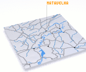 Places with similar names to Mata Velha, Brazil ::
// Mato Velho (PT)
// Mata Velha (BR)
Disclaimer :: Information on this page comes without warranty of any kind |
||
|
Where is Mata Velha? Elevation and coordinates ::
Latitude (lat): 3°13'16"S Longitude (lon): 42°20'37"W
Elevation (approx.): 74m (map arrows pan, magnifying glasses zoom) |
||
|
Visiting Mata Velha? Hotel/Accommodation ::
Book a hotel in Mata Velha Travel Guide ::
Buy a travel guide for Brazil rental cars ::
car rental offers GPS waypoint ::
download a GPX waypoint (PoI) of Mata Velha for your GPS receiver
|
||