|
search place name
|
||
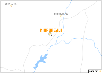
Mina Brejuí (Rio Grande do Norte, Brazil)Mina Brejuí is a town in the Rio Grande do Norte region of Brazil. An overview map of the region around Mina Brejuí is displayed below.
regional and 3d topo map of Mina Brejuí, Brazil ::
Mina Brejuí airports ::
The nearest airport is CPV - Campina Grande Presidente Joao Suassuna, located 127.8 km south east of Mina Brejuí.
Other airports nearby include NAT - Natal Augusto Severo (151.0 km east), JPA - Joao Pessoa Presidente Castro Pinto (199.3 km south east), REC - Recife Guararapes Gilberto Freyre Intl (269.0 km south east), Nearby towns ::
Currais Novos (8.3km north east) //
[all distances 'as the bird flies' and approximate]  Places with similar names to Mina Brejuí, Brazil ::
// Miāni Borgi (PK)
// Menai Bridge (GB)
// Maine Bridge (IE)
// Meen Bridge (IE)
// Mine Bridge (IE)
// Money Bridge (IE)
// Moyne Bridge (IE)
// Moyny Bridge (IE)
Disclaimer :: Information on this page comes without warranty of any kind |
||
|
Where is Mina Brejuí? Elevation and coordinates ::
Latitude (lat): 6°19'0"S Longitude (lon): 36°33'0"W
Elevation (approx.): 438m (map arrows pan, magnifying glasses zoom) |
||
|
Visiting Mina Brejuí? Hotel/Accommodation ::
Book a hotel in Mina Brejuí Travel Guide ::
Buy a travel guide for Brazil rental cars ::
car rental offers GPS waypoint ::
download a GPX waypoint (PoI) of Mina Brejuí for your GPS receiver
|
||