|
search place name
|
||
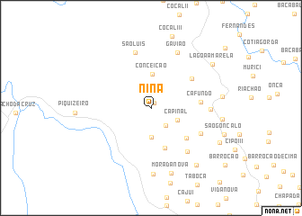
Nina (Maranhão, Brazil)Nina is a town in the Maranhão region of Brazil. An overview map of the region around Nina is displayed below.
regional and 3d topo map of Nina, Brazil ::
Nina airports ::
The nearest airport is SLZ - Sao Luis Marechal Cunha Machado Intl, located 139.8 km north west of Nina.
Other airports nearby include THE - Teresina Senador Petronio Portella (176.8 km south east), Nearby towns ::
Bacaba I (0.7km north east) //
Capínal I (2.8km south east) //
Capínal (3.7km south east) //
Ventura (3.7km south) //
Conceição (4.1km north) //
Alpercata (5.2km south) //
Banana (5.8km south east) //
Centro dos Paulos (6.2km north east) //
Cafundó (6.2km east) //
Centro dos Ferreiras (6.9km south east) //
Periquito (7.1km south east) //
São Luís (7.1km north) //
São Clemente (7.4km east) //
Gavião (7.7km north east) //
Boqueirãozinho (8.2km south) //
Morada Nova (8.5km south) //
Oiteiro (9.0km east) //
São Fernando (9.0km east) //
Caldeirão (9.1km south east) //
Cocal III (9.2km north) //
Lagoa Amarela (9.4km north east) //
São Gonçalo de Baixo (9.5km south east) //
[all distances 'as the bird flies' and approximate] 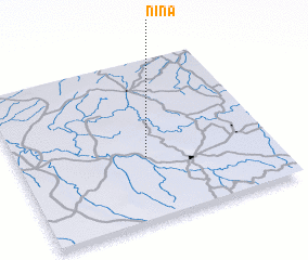 Places with similar names to Nina, Brazil ::
Disclaimer :: Information on this page comes without warranty of any kind |
||
|
Where is Nina? Elevation and coordinates ::
Latitude (lat): 3°36'41"S Longitude (lon): 43°29'55"W
Elevation (approx.): 48m (map arrows pan, magnifying glasses zoom) |
||
|
Visiting Nina? Hotel/Accommodation ::
Book a hotel in Nina Travel Guide ::
Buy a travel guide for Brazil rental cars ::
car rental offers GPS waypoint ::
download a GPX waypoint (PoI) of Nina for your GPS receiver
|
||