|
search place name
|
||
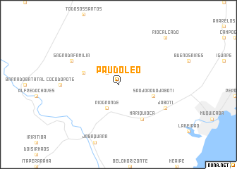
Pau dʼÓleo (Espírito Santo, Brazil)Pau dʼÓleo is a town in the Espírito Santo region of Brazil. An overview map of the region around Pau dʼÓleo is displayed below.
regional and 3d topo map of Pau dʼÓleo, Brazil ::
Pau dʼÓleo airports ::
The nearest airport is VIX - Vitoria Goiabeiras, located 53.7 km north east of Pau dʼÓleo.
Other airports nearby include CAW - Campos Bartolomeu Lisandro (138.4 km south west), IPN - Ipatinga Usiminas (231.8 km north west), Nearby towns ::
São Miguel (2.5km north west) //
Rio Grande (4.1km south west) //
São João do Jaboti (5.5km east) //
São José do Rio dos Veados (5.5km west) //
Mariquioca (6.6km south east) //
Jaboti (7.9km south east) //
Sagrada Família (7.9km north west) //
Rio Calçado (10.2km north east) //
[all distances 'as the bird flies' and approximate] 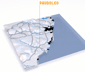 Places with similar names to Pau dʼÓleo, Brazil ::
Disclaimer :: Information on this page comes without warranty of any kind |
||
|
Where is Pau dʼÓleo? Elevation and coordinates ::
Latitude (lat): 20°37'0"S Longitude (lon): 40°38'0"W
Elevation (approx.): 422m (map arrows pan, magnifying glasses zoom) |
||
|
Visiting Pau dʼÓleo? Hotel/Accommodation ::
Book a hotel in Pau dʼÓleo Travel Guide ::
Buy a travel guide for Brazil rental cars ::
car rental offers GPS waypoint ::
download a GPX waypoint (PoI) of Pau dʼÓleo for your GPS receiver
|
||