|
search place name
|
||
Pôrto Guaíra (São Paulo, Brazil)Pôrto Guaíra is a town in the São Paulo region of Brazil. An overview map of the region around Pôrto Guaíra is displayed below.
regional and 3d topo map of Pôrto Guaíra, Brazil ::

Pôrto Guaíra airports ::
The nearest airport is UBA - Uberaba, located 87.3 km north east of Pôrto Guaíra.
Other airports nearby include SJP - Sao Jose Do Rio Preto (107.5 km south west), RAO - Ribeirao Preto Leite Lopes (111.2 km south east), AQA - Araracuara Araraquara (162.3 km south), UDI - Uberlandia Ten Cel Av Cesar Bombonato (168.3 km north), Nearby towns ::
Pôrto Joaquim Justino (7.6km south east) //
[all distances 'as the bird flies' and approximate] 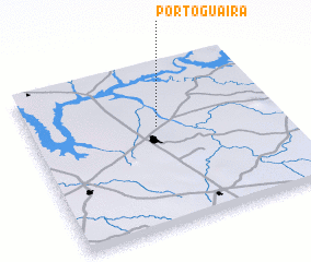 Places with similar names to Pôrto Guaíra, Brazil ::
// Porto Correia (BR)
// Pôrto Guareí (BR)
// Per Tokar (ER)
// Perticara (IT)
// Perdigueira (PT)
// Porto Carro (PT)
// Perdiguera (ES)
// Parādagār (BD)
// Pārtekur (BD)
// Puerto Grau (CO)
Disclaimer :: Information on this page comes without warranty of any kind |
||
|
Where is Pôrto Guaíra? Elevation and coordinates ::
Latitude (lat): 20°23'0"S Longitude (lon): 48°29'0"W
Elevation (approx.): 451m (map arrows pan, magnifying glasses zoom) |
||
|
Visiting Pôrto Guaíra? Hotel/Accommodation ::
Book a hotel in Pôrto Guaíra Travel Guide ::
Buy a travel guide for Brazil rental cars ::
car rental offers GPS waypoint ::
download a GPX waypoint (PoI) of Pôrto Guaíra for your GPS receiver
|
||