|
search place name
|
||
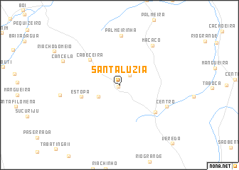
Santa Luzia (Maranhão, Brazil)Santa Luzia is a town in the Maranhão region of Brazil. An overview map of the region around Santa Luzia is displayed below.
regional and 3d topo map of Santa Luzia, Brazil ::
Santa Luzia airports ::
The nearest airport is SLZ - Sao Luis Marechal Cunha Machado Intl, located 160.2 km west of Santa Luzia.
Other airports nearby include THE - Teresina Senador Petronio Portella (213.2 km south), Nearby towns ::
Mamede (0.3km south west) //
Onça do Salvador (2.2km north east) //
Onça dos Paneiros (3.7km south west) //
Andreza (4.6km north east) //
Cabeceira (6.0km north west) //
Estopa (6.3km west) //
Guarimã Grande (7.0km south east) //
Palmeirinha (7.8km north) //
Macaco (8.0km north east) //
Centro (8.1km south east) //
Cancela (9.5km north west) //
[all distances 'as the bird flies' and approximate] 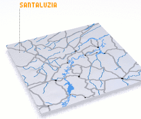 Places with similar names to Santa Luzia, Brazil ::
// Santa Alice (BR)
// Santa Elisa (BR)
// Santa Elisa (BR)
// Santa Eloísa (BR)
// Santa Luísa (BR)
// Santa Luísa (BR)
// Santa Luiza (BR)
// Santa Luz (BR)
// Santa Luzia (BR)
// Santa Luzia (BR)
Disclaimer :: Information on this page comes without warranty of any kind |
||
|
Where is Santa Luzia? Elevation and coordinates ::
Latitude (lat): 3°8'0"S Longitude (lon): 42°54'0"W
Elevation (approx.): 50m (map arrows pan, magnifying glasses zoom) |
||
|
Visiting Santa Luzia? Hotel/Accommodation ::
Book a hotel in Santa Luzia Travel Guide ::
Buy a travel guide for Brazil rental cars ::
car rental offers GPS waypoint ::
download a GPX waypoint (PoI) of Santa Luzia for your GPS receiver
|
||