|
search place name
|
||
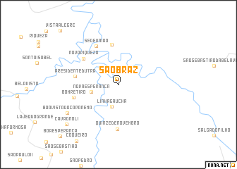
São Braz (Parana, Brazil)São Braz is a town in the Parana region of Brazil. An overview map of the region around São Braz is displayed below.
regional and 3d topo map of São Braz, Brazil ::
São Braz airports ::
The nearest airport is IGR - Iguazu Falls Cataratas Del Iguazu, located 105.0 km west of São Braz.
Other airports nearby include IGU - Foz Do Iguacu Cataratas Intl (113.0 km north west), CAC - Cascavel (121.1 km north), XAP - Chapeco (142.8 km south east), Nearby towns ::
Linha Gaúcha (3.7km south) //
Nova Esperança (4.0km west) //
Linha Sarandi (6.3km north) //
Nova Riqueza (6.4km north west) //
Presidente Dutra (6.3km west) //
Sede União (6.9km north west) //
Quinze de Novembro (7.1km south) //
Bom Retiro (6.7km west) //
Bóa Vista do Capanema (8.6km south west) //
Cavagnoli (9.7km south west) //
[all distances 'as the bird flies' and approximate] 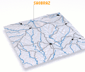 Places with similar names to São Braz, Brazil ::
Disclaimer :: Information on this page comes without warranty of any kind |
||
|
Where is São Braz? Elevation and coordinates ::
Latitude (lat): 26°5'37"S Longitude (lon): 53°30'10"W
Elevation (approx.): 549m (map arrows pan, magnifying glasses zoom) |
||
|
Visiting São Braz? Hotel/Accommodation ::
Book a hotel in São Braz Travel Guide ::
Buy a travel guide for Brazil rental cars ::
car rental offers GPS waypoint ::
download a GPX waypoint (PoI) of São Braz for your GPS receiver
|
||