|
search place name
|
||
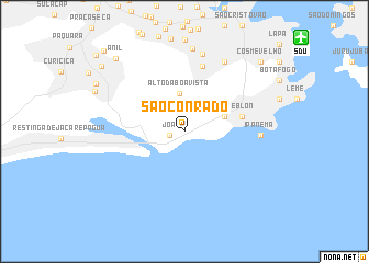
São Conrado (Rio de Janeiro, Brazil)São Conrado is a town in the Rio de Janeiro region of Brazil. An overview map of the region around São Conrado is displayed below.
regional and 3d topo map of São Conrado, Brazil ::
São Conrado airports ::
The nearest airport is SDU - Rio De Janeiro Santos Dumont, located 14.5 km north east of São Conrado.
Other airports nearby include GIG - Rio De Janeiro Galeao Antonio Carlos Jobim (21.0 km north), STU - Rio De Janeiro Santa Cruz (46.6 km west), JDF - Juiz De Fora Francisco De Assis (134.0 km north), CAW - Campos Bartolomeu Lisandro (248.5 km north east), Nearby towns ::
Joá (1.4km west) //
Alto da Boa Vista (3.9km north) //
Gávea (4.0km east) //
Leblon (5.6km east) //
Arrelia (6.9km north) //
Ipanema (7.1km east) //
Catumbi (7.1km east) //
Andaraí (8.1km north) //
Tijuca (8.0km north east) //
Crajaú (8.4km north) //
Anil (9.8km north west) //
Cosme Velho (10.0km north east) //
Freguesia (10.2km north west) //
Engenho da Serra (11.1km north west) //
[all distances 'as the bird flies' and approximate]  Places with similar names to São Conrado, Brazil ::
// Schönried (CH)
// Sackenried (DE)
// Schönreit (DE)
// Cigányrét (HU)
// Skoonoord (ZA)
// Signirti (TD)
// Zuckenriet (CH)
// Schoonoord (NL)
// Skåneröd (SE)
// Skinnerud (SE)
Disclaimer :: Information on this page comes without warranty of any kind |
||
|
Where is São Conrado? Elevation and coordinates ::
Latitude (lat): 22°59'48"S Longitude (lon): 43°16'11"W
Elevation (approx.): 26m (map arrows pan, magnifying glasses zoom) |
||
|
Visiting São Conrado? Hotel/Accommodation ::
Book a hotel in São Conrado Travel Guide ::
Buy a travel guide for Brazil rental cars ::
car rental offers GPS waypoint ::
download a GPX waypoint (PoI) of São Conrado for your GPS receiver
|
||