|
search place name
|
||
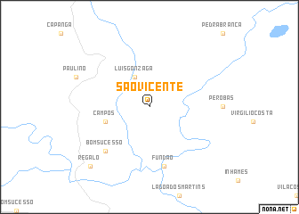
São Vicente (Minas Gerais, Brazil)São Vicente is a town in the Minas Gerais region of Brazil. An overview map of the region around São Vicente is displayed below.
regional and 3d topo map of São Vicente, Brazil ::
São Vicente airports ::
The nearest airport is VAG - Varginha Major Brigadeiro Trompowsky, located 155.8 km south of São Vicente.
Other airports nearby include POO - Pocos De Caldas (184.8 km south), RAO - Ribeirao Preto Leite Lopes (209.8 km south west), UBA - Uberaba (214.6 km west), QPS - Piracununga Campo Fontenelle (236.4 km south west), Nearby towns ::
Luís Gonzaga (4.1km north west) //
Campos (5.5km west) //
Fundão (7.6km south) //
Bom Sucesso (7.6km south west) //
Regalo (10.2km south west) //
[all distances 'as the bird flies' and approximate] 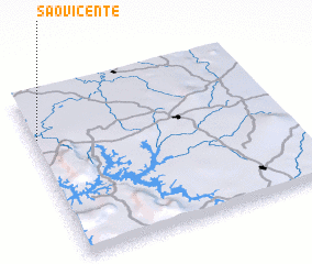 Places with similar names to São Vicente, Brazil ::
// São Vicente (BR)
// São Vicente (BR)
// São Vicente (BR)
// São Vicente (BR)
// São Vicente (BR)
// São Vicente (BR)
// São Vicente (BR)
// São Vicente (BR)
// São Vicente (BR)
// São Vicente (BR)
Disclaimer :: Information on this page comes without warranty of any kind |
||
|
Where is São Vicente? Elevation and coordinates ::
Latitude (lat): 20°16'0"S Longitude (lon): 45°59'0"W
Elevation (approx.): 677m (map arrows pan, magnifying glasses zoom) |
||
|
Visiting São Vicente? Hotel/Accommodation ::
Book a hotel in São Vicente Travel Guide ::
Buy a travel guide for Brazil rental cars ::
car rental offers GPS waypoint ::
download a GPX waypoint (PoI) of São Vicente for your GPS receiver
|
||