|
search place name
|
||
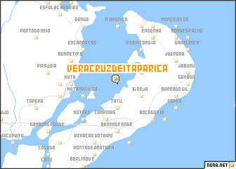
Vera Cruz de Itaparica (Bahia, Brazil)Vera Cruz de Itaparica is a town in the Bahia region of Brazil. An overview map of the region around Vera Cruz de Itaparica is displayed below.
regional and 3d topo map of Vera Cruz de Itaparica, Brazil ::
Vera Cruz de Itaparica airports ::
The nearest airport is SSA - Salvador Deputado Luis Eduardo Magalhaes, located 40.8 km east of Vera Cruz de Itaparica.
Other airports nearby include IOS - Ilheus (205.9 km south), AJU - Aracaju Santa Maria (283.6 km north east), Nearby towns ::
Tatu (3.7km south) //
Ponta Grossa (3.7km south) //
Boa Vista (4.1km north east) //
Igreja (4.1km south east) //
Matarandiba (5.7km west) //
Campinas (5.8km south) //
Misericórdia (6.6km north east) //
Mutá (7.2km west) //
Barra Grande (7.4km south) //
Matões (7.8km south west) //
Encarnação (7.8km north west) //
Bôca do Rio (7.8km south east) //
Bom Retiro (8.1km north west) //
Engenho (9.2km north east) //
Conceição (9.1km south east) //
Barra do Pote (9.1km south east) //
[all distances 'as the bird flies' and approximate] 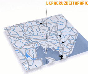 Places with similar names to Vera Cruz de Itaparica, Brazil :: Disclaimer :: Information on this page comes without warranty of any kind |
||
|
Where is Vera Cruz de Itaparica? Elevation and coordinates ::
Latitude (lat): 12°59'0"S Longitude (lon): 38°42'0"W
Elevation (approx.): 2m (map arrows pan, magnifying glasses zoom) |
||
|
Visiting Vera Cruz de Itaparica? Hotel/Accommodation ::
Book a hotel in Vera Cruz de Itaparica Travel Guide ::
Buy a travel guide for Brazil rental cars ::
car rental offers GPS waypoint ::
download a GPX waypoint (PoI) of Vera Cruz de Itaparica for your GPS receiver
|
||