|
search place name
|
||
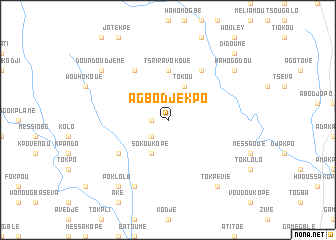
Agbodjekpo (Togo)Agbodjekpo is a town in Togo. An overview map of the region around Agbodjekpo is displayed below.
regional and 3d topo map of Agbodjekpo, Togo ::
Agbodjekpo airports ::
The nearest airport is LFW - Lome Gnassingbe Eyadema Intl, located 78.4 km south of Agbodjekpo.
Other airports nearby include COO - Cotonou Cadjehoun (160.2 km east), ACC - Accra Kotoka Intl (188.7 km south west), Nearby towns ::
Vedomé (1.8km west) //
Kotiokopé (1.8km west) //
Akakpodjé (2.6km south west) //
Agbolokopé (4.1km south west) //
Sokoukopé (4.1km south west) //
Tokou (4.1km north east) //
Tsriravokoué (5.6km north) //
Fokpoé (6.6km south west) //
Missahomé (6.7km north east) //
Batoumé (6.7km north west) //
Atikolé (8.3km south west) //
Poklolo (9.2km south west) //
Tokpévié (9.2km south east) //
Hahogodou (9.2km north east) //
Doundoudjemé (9.2km north west) //
Didoumé (10.4km north east) //
Agokpo (10.4km north east) //
[all distances 'as the bird flies' and approximate] 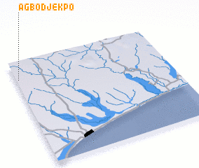 Places with similar names to Agbodjekpo, Togo ::
// Agbédjikpo (TG)
Disclaimer :: Information on this page comes without warranty of any kind |
||
|
Where is Agbodjekpo? Elevation and coordinates ::
Latitude (lat): 6°50'0"N Longitude (lon): 1°1'0"E
Elevation (approx.): 147m (map arrows pan, magnifying glasses zoom) |
||
|
Visiting Agbodjekpo? Hotel/Accommodation ::
Book a hotel in Agbodjekpo Travel Guide ::
Buy a travel guide for Togo rental cars ::
car rental offers GPS waypoint ::
download a GPX waypoint (PoI) of Agbodjekpo for your GPS receiver
|
||