|
search place name
|
||
Asato (Préfecture de Lomé, Togo)Asato is a town in the Préfecture de Lomé region of Togo. An overview map of the region around Asato is displayed below.
regional and 3d topo map of Asato, Togo ::

Asato airports ::
The nearest airport is LFW - Lome Gnassingbe Eyadema Intl, located 12.1 km east of Asato.
Other airports nearby include COO - Cotonou Cadjehoun (138.4 km east), ACC - Accra Kotoka Intl (158.7 km south west), Nearby towns ::
Davo (0.2km east) //
Yokoé (0.6km south) //
Pasra (0.7km south east) //
Kpésoudji (0.8km north) //
Mésan (0.9km south) //
Wonyomé (0.9km north east) //
Adjivon (1.0km north) //
Sagbado Agotimé (1.0km south west) //
Yokoé Kopégan (1.1km south) //
Sagbado (1.4km north west) //
Avého (1.4km west) //
Sagbado Logoté (1.5km north west) //
Sakani (1.5km west) //
Agbédinou (1.7km north) //
Adedido (2.1km south) //
Lankouvé (2.1km south west) //
Avoémé (2.1km south west) //
Adido Gomé (2.1km east) //
Gbouamé (2.1km north west) //
Kosi (2.3km north) //
Djakli (2.3km north) //
Rhétchevi (2.4km north east) //
Agbéménya (2.4km south west) //
Darege (2.5km south west) //
Djanyipémé (2.5km north east) //
Madéomé (2.6km north) //
Godéka (2.6km north west) //
Tiglikpo (2.6km east) //
Kagavé (2.6km west) //
[all distances 'as the bird flies' and approximate] 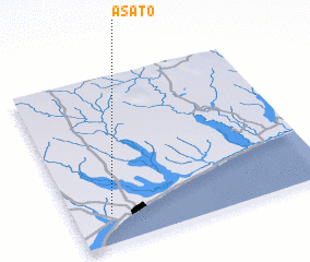 Places with similar names to Asato, Togo ::
Disclaimer :: Information on this page comes without warranty of any kind |
||
|
Where is Asato? Elevation and coordinates ::
Latitude (lat): 6°10'51"N Longitude (lon): 1°8'46"E
Elevation (approx.): 30m (map arrows pan, magnifying glasses zoom) |
||
|
Visiting Asato? Hotel/Accommodation ::
Book a hotel in Asato Travel Guide ::
Buy a travel guide for Togo rental cars ::
car rental offers GPS waypoint ::
download a GPX waypoint (PoI) of Asato for your GPS receiver
|
||