|
search place name
|
||
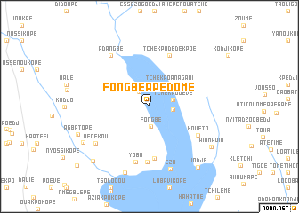
Fongbé Apédomé (Tsévié Préfecture de, Togo)Fongbé Apédomé is a town in the Tsévié Préfecture de region of Togo. An overview map of the region around Fongbé Apédomé is displayed below.
regional and 3d topo map of Fongbé Apédomé, Togo ::
Fongbé Apédomé airports ::
The nearest airport is LFW - Lome Gnassingbe Eyadema Intl, located 35.7 km south of Fongbé Apédomé.
Other airports nearby include COO - Cotonou Cadjehoun (115.8 km east), ACC - Accra Kotoka Intl (193.0 km south west), LOS - Lagos Murtala Muhammed (219.0 km east), Nearby towns ::
Éssoun (2.3km north west) //
Fongbé (2.6km south) //
Nyagbali Kopé (3.0km east) //
Gati (3.0km north west) //
Tchékpo Dévé (3.0km east) //
Tchekpo Anagani (3.7km north east) //
Agbalamé (6.5km south) //
Rhodémi (6.9km north) //
Tchekpo Dédékpoé (6.9km north) //
Sédjro (7.0km south) //
Kovéto (7.0km south east) //
Yobo (7.2km south) //
Adangbé (8.1km north west) //
Védékou (8.2km south west) //
Ezo (8.3km south) //
Agbaté Kopé (8.9km south) //
Animaoio (9.3km south east) //
Davédé (9.4km south west) //
Vodjé (9.8km south east) //
Kaguenkopé (9.8km south west) //
[all distances 'as the bird flies' and approximate] 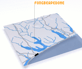 Places with similar names to Fongbé Apédomé, Togo :: Disclaimer :: Information on this page comes without warranty of any kind |
||
|
Where is Fongbé Apédomé? Elevation and coordinates ::
Latitude (lat): 6°28'31"N Longitude (lon): 1°20'39"E
Elevation (approx.): 32m (map arrows pan, magnifying glasses zoom) |
||
|
Visiting Fongbé Apédomé? Hotel/Accommodation ::
Book a hotel in Fongbé Apédomé Travel Guide ::
Buy a travel guide for Togo rental cars ::
car rental offers GPS waypoint ::
download a GPX waypoint (PoI) of Fongbé Apédomé for your GPS receiver
|
||