|
search place name
|
||
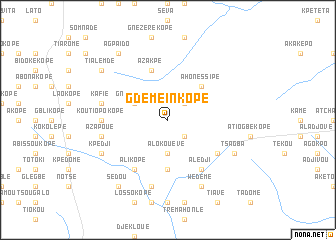
Gdémeinkopé (Togo)Gdémeinkopé is a town in Togo. An overview map of the region around Gdémeinkopé is displayed below.
regional and 3d topo map of Gdémeinkopé, Togo ::
Gdémeinkopé airports ::
The nearest airport is LFW - Lome Gnassingbe Eyadema Intl, located 94.1 km south of Gdémeinkopé.
Other airports nearby include COO - Cotonou Cadjehoun (143.5 km south east), ACC - Accra Kotoka Intl (222.5 km south west), Nearby towns ::
Atilkavé (2.6km north east) //
Kabrékopé (2.6km south east) //
Ténanékopé (2.6km south east) //
Alokouévé (3.7km south) //
Gninokopé (4.1km north west) //
Loloboavé (5.2km north east) //
Ahonéssipé (5.2km north east) //
Aguéloufé (5.6km south) //
Azakpé (5.9km north) //
Alédji (6.7km south east) //
Alikopé (6.7km south west) //
Goédékopé (6.6km south east) //
Empékopé (6.6km south east) //
Koutiopokopé (7.4km west) //
Kafié (7.6km west) //
Djéminimotonou (7.6km south) //
Azapoué (7.6km west) //
Tsagba (8.2km south east) //
Amégadé (8.2km south east) //
Wédémé (8.3km south east) //
Povékopé (8.3km south east) //
Kpédji (8.2km south west) //
Agpaïdo (9.2km north west) //
Sedou (9.2km south west) //
Tialemdé (9.2km north west) //
[all distances 'as the bird flies' and approximate]  Places with similar names to Gdémeinkopé, Togo :: Disclaimer :: Information on this page comes without warranty of any kind |
||
|
Where is Gdémeinkopé? Elevation and coordinates ::
Latitude (lat): 7°1'0"N Longitude (lon): 1°16'0"E
Elevation (approx.): 158m (map arrows pan, magnifying glasses zoom) |
||
|
Visiting Gdémeinkopé? Hotel/Accommodation ::
Book a hotel in Gdémeinkopé Travel Guide ::
Buy a travel guide for Togo rental cars ::
car rental offers GPS waypoint ::
download a GPX waypoint (PoI) of Gdémeinkopé for your GPS receiver
|
||