|
search place name
|
||
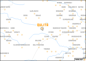
Oulita (Togo)Oulita is a town in Togo. An overview map of the region around Oulita is displayed below.
regional and 3d topo map of Oulita, Togo ::
Oulita airports ::
The nearest airport is LFW - Lome Gnassingbe Eyadema Intl, located 154.0 km south of Oulita.
Other airports nearby include COO - Cotonou Cadjehoun (206.8 km south east), ACC - Accra Kotoka Intl (243.0 km south west), Nearby towns ::
Béna (2.6km north west) //
Adjahoun (3.7km south) //
Ayomé (4.1km south east) //
Ezimé (4.1km south east) //
Amlamé (5.9km south) //
Oudjé (5.9km north) //
Edifou (6.6km south east) //
Agomé Kotoukpa (7.3km east) //
Dédomé (7.6km east) //
Oulita Hohoé (7.6km south) //
Agadji (7.6km south) //
Djalouma (8.3km north west) //
Ounabé (9.2km north east) //
Okou (9.2km north west) //
Amoussa (10.4km north east) //
[all distances 'as the bird flies' and approximate] 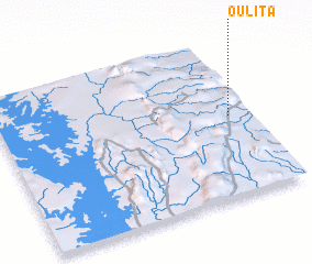 Places with similar names to Oulita, Togo ::
Disclaimer :: Information on this page comes without warranty of any kind |
||
|
Where is Oulita? Elevation and coordinates ::
Latitude (lat): 7°31'0"N Longitude (lon): 0°55'0"W
Elevation (approx.): 628m (map arrows pan, magnifying glasses zoom) |
||
|
Visiting Oulita? Hotel/Accommodation ::
Book a hotel in Oulita Travel Guide ::
Buy a travel guide for Togo rental cars ::
car rental offers GPS waypoint ::
download a GPX waypoint (PoI) of Oulita for your GPS receiver
|
||