|
search place name
|
||
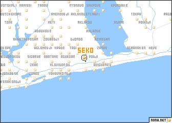
Séko (Togo)Séko is a town in Togo. An overview map of the region around Séko is displayed below.
regional and 3d topo map of Séko, Togo ::
Séko airports ::
The nearest airport is LFW - Lome Gnassingbe Eyadema Intl, located 52.4 km west of Séko.
Other airports nearby include COO - Cotonou Cadjehoun (74.6 km east), LOS - Lagos Murtala Muhammed (180.8 km east), ACC - Accra Kotoka Intl (221.0 km west), Nearby towns ::
Sibamé (1.9km north) //
Podji (1.8km east) //
Akpouta Kopé (1.9km south) //
Séko Kopé (1.9km south) //
Tagbamé (2.6km north west) //
Mikoumé Kondji (2.6km north west) //
Ougatomé (2.6km north west) //
Kanyi Kondji (2.6km north west) //
Kodjoui Kopé (2.6km south east) //
Syanou Kopé (2.6km south east) //
Djéta (3.7km east) //
Agwégan (3.7km west) //
Médélou (3.7km west) //
Zanvé (4.1km north east) //
Djondo (4.1km north west) //
Aviguénou (4.1km south east) //
Djoundou Yondo (4.1km north west) //
Klomavi Kopé (4.1km south west) //
Azimégan (5.2km north east) //
Amadou (5.2km north west) //
Agoué (5.2km south west) //
Nicouécodji (5.5km east) //
Rhlandé (5.9km north) //
Kpadé (5.8km west) //
Bakari (5.8km east) //
Dakondji (5.8km west) //
Klovidonou (5.8km west) //
Atwéta (6.7km north west) //
Safénou (6.7km north west) //
[all distances 'as the bird flies' and approximate]  Places with similar names to Séko, Togo ::
Disclaimer :: Information on this page comes without warranty of any kind |
||
|
Where is Séko? Elevation and coordinates ::
Latitude (lat): 6°16'0"N Longitude (lon): 1°43'0"E
Elevation (approx.): 5m (map arrows pan, magnifying glasses zoom) |
||
|
Visiting Séko? Hotel/Accommodation ::
Book a hotel in Séko Travel Guide ::
Buy a travel guide for Togo rental cars ::
car rental offers GPS waypoint ::
download a GPX waypoint (PoI) of Séko for your GPS receiver
|
||