|
search place name
|
||
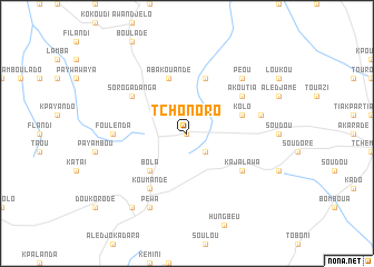
Tchonoro (Togo)Tchonoro is a town in Togo. An overview map of the region around Tchonoro is displayed below.
regional and 3d topo map of Tchonoro, Togo ::
Tchonoro airports ::
The nearest airport is LRL - Niatougou Niamtougou International, located 50.0 km north of Tchonoro.
Nearby towns ::
Bafilo (0.0km north) //
Bodoudé (2.6km south east) //
Bola (5.2km south west) //
Kajamboué (5.9km north) //
Kolo (5.8km east) //
Abakouandé (5.9km north) //
Kajalawa (6.6km south east) //
Akoutia (6.6km north east) //
Djandjé (6.6km north east) //
Sorogadanga (6.6km north west) //
Afoudi (6.6km north west) //
Koumandé (6.7km south west) //
Foulenda (7.3km west) //
Gandé (7.5km east) //
Péou (7.8km north east) //
Péwa (8.3km south west) //
Agaradé (9.2km south west) //
[all distances 'as the bird flies' and approximate]  Places with similar names to Tchonoro, Togo ::
// Toshnur (RU)
// Tichnor (US)
// Deh Chenār (IR)
// Deh Chenār (IR)
// Duchinora (TJ)
// Tashnur (RU)
// Toshner (RU)
// Dashui Nur (CN)
Disclaimer :: Information on this page comes without warranty of any kind |
||
|
Where is Tchonoro? Elevation and coordinates ::
Latitude (lat): 9°21'0"N Longitude (lon): 1°16'0"E
Elevation (approx.): 616m (map arrows pan, magnifying glasses zoom) |
||
|
Visiting Tchonoro? Hotel/Accommodation ::
Book a hotel in Tchonoro Travel Guide ::
Buy a travel guide for Togo rental cars ::
car rental offers GPS waypoint ::
download a GPX waypoint (PoI) of Tchonoro for your GPS receiver
|
||