|
search place name
|
||
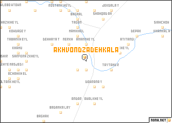
Ākhvond Zādeh Kalā (Vardak, Afghanistan)Ākhvond Zādeh Kalā is a town in the Vardak region of Afghanistan. An overview map of the region around Ākhvond Zādeh Kalā is displayed below.
regional and 3d topo map of Ākhvond Zādeh Kalā, Afghanistan ::
Ākhvond Zādeh Kalā airports ::
The nearest airport is KBL - Kabul Intl, located 43.3 km north east of Ākhvond Zādeh Kalā.
Other airports nearby include JAA - Jalalabad (153.4 km east), Nearby towns ::
Sūr Pol (1.9km south) //
Sar-e Ghonḏī (1.9km south) //
Bar Shāh Kābul (2.4km south west) //
Amar Kheyl (3.7km north) //
Kān-e ‘Ezat (4.8km north west) //
Nerkh (4.8km north west) //
Tay Tamūr (5.0km east) //
Khoshkak Darrah (5.0km east) //
Mamī Khēl (5.8km north) //
Dowrānay (5.8km south) //
Chagharah (6.3km south east) //
Tagān (7.6km north) //
Māshī Kheyl (6.4km east) //
Deh Ḩayāt (7.2km north west) //
[all distances 'as the bird flies' and approximate] 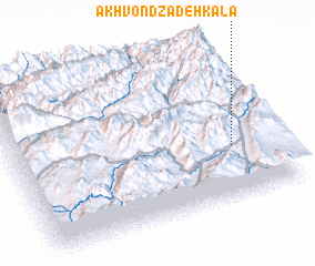 Places with similar names to Ākhvond Zādeh Kalā, Afghanistan :: Disclaimer :: Information on this page comes without warranty of any kind |
||
|
Where is Ākhvond Zādeh Kalā? Elevation and coordinates ::
Latitude (lat): 34°20'0"N Longitude (lon): 68°50'0"E
Elevation (approx.): 2169m (map arrows pan, magnifying glasses zoom) |
||
|
Visiting Ākhvond Zādeh Kalā? Hotel/Accommodation ::
Book a hotel in Ākhvond Zādeh Kalā Travel Guide ::
Buy a travel guide for Afghanistan rental cars ::
car rental offers GPS waypoint ::
download a GPX waypoint (PoI) of Ākhvond Zādeh Kalā for your GPS receiver
|
||