|
search place name
|
||
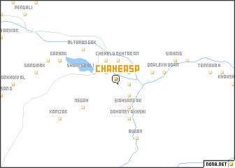
Chāh-e Asp (Ghaznī, Afghanistan)Chāh-e Asp is a town in the Ghaznī region of Afghanistan. An overview map of the region around Chāh-e Asp is displayed below.
regional and 3d topo map of Chāh-e Asp, Afghanistan ::
Chāh-e Asp airports ::
The nearest airport is KBL - Kabul Intl, located 124.0 km north east of Chāh-e Asp.
Nearby towns ::
Dahan-e Shūr Āb (1.5km east) //
Torghah (2.4km south east) //
Kārīz-e Eslāmā (2.4km north east) //
Owbeh Karam (2.4km north east) //
Shahr-e Pā'īn-e Khavāt (2.4km north west) //
Do Borjeh (3.7km north) //
Chehel Dokhtarān (3.7km north) //
Sīāh Sangak (4.0km south east) //
Katowk-e Sabz Āb (4.0km north) //
Godowl (3.6km north west) //
Shahr-e Bālā-ye Khavāt (3.6km north west) //
Dahan-e Yakhshī (5.8km south) //
Būlāqarah (5.8km south) //
Kolūkh (5.8km south) //
Nowē Qal‘ah (5.0km east) //
Negah (5.9km south west) //
Qowl-e Khūgān (6.4km east) //
Altar Āngak (7.2km north west) //
Zardargīn (7.2km north west) //
Būkān (9.0km south) //
[all distances 'as the bird flies' and approximate] 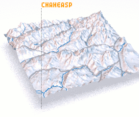 Places with similar names to Chāh-e Asp, Afghanistan :: Disclaimer :: Information on this page comes without warranty of any kind |
||
|
Where is Chāh-e Asp? Elevation and coordinates ::
Latitude (lat): 34°3'0"N Longitude (lon): 68°1'0"E
Elevation (approx.): 2849m (map arrows pan, magnifying glasses zoom) |
||
|
Visiting Chāh-e Asp? Hotel/Accommodation ::
Book a hotel in Chāh-e Asp Travel Guide ::
Buy a travel guide for Afghanistan rental cars ::
car rental offers GPS waypoint ::
download a GPX waypoint (PoI) of Chāh-e Asp for your GPS receiver
|
||