|
search place name
|
||
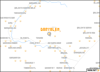
Daryālem (Vardak, Afghanistan)Daryālem is a town in the Vardak region of Afghanistan. An overview map of the region around Daryālem is displayed below.
regional and 3d topo map of Daryālem, Afghanistan ::
Daryālem airports ::
The nearest airport is KBL - Kabul Intl, located 41.9 km east of Daryālem.
Other airports nearby include JAA - Jalalabad (159.4 km east), Nearby towns ::
Bālā Deh (1.5km east) //
Qowl (2.4km north east) //
Pol-e Chahār Deh (3.7km south) //
Tēbah (3.7km south) //
Kowt-e ‘Ashrow (4.0km south) //
Meydān Shahr (4.0km south) //
Kohneh Deh (3.6km north east) //
Tēshah (3.6km south west) //
Rostam Kheyl (5.8km south) //
Chahār Qal‘eh (6.3km south east) //
Zīvelāyat (5.9km south west) //
Seyyed Shāh Kheyl (6.3km south west) //
Bosrāq (7.2km south east) //
Levān (7.1km south east) //
Aḩmad Khān Kalā (8.7km south east) //
Baghal (8.7km south east) //
Sīāh Pītāv (8.7km south east) //
[all distances 'as the bird flies' and approximate]  Places with similar names to Daryālem, Afghanistan :: Disclaimer :: Information on this page comes without warranty of any kind |
||
|
Where is Daryālem? Elevation and coordinates ::
Latitude (lat): 34°29'0"N Longitude (lon): 68°46'0"E
Elevation (approx.): 2630m (map arrows pan, magnifying glasses zoom) |
||
|
Visiting Daryālem? Hotel/Accommodation ::
Book a hotel in Daryālem Travel Guide ::
Buy a travel guide for Afghanistan rental cars ::
car rental offers GPS waypoint ::
download a GPX waypoint (PoI) of Daryālem for your GPS receiver
|
||