|
search place name
|
||
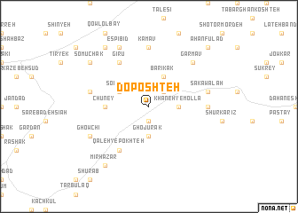
Do Poshteh (Vardak, Afghanistan)Do Poshteh is a town in the Vardak region of Afghanistan. An overview map of the region around Do Poshteh is displayed below.
regional and 3d topo map of Do Poshteh, Afghanistan ::
Do Poshteh airports ::
The nearest airport is KBL - Kabul Intl, located 110.8 km east of Do Poshteh.
Nearby towns ::
Sorkh Qal‘eh (1.9km south) //
Ramzī (1.9km south) //
Gandow (2.4km north east) //
Ghojūrak (3.7km south) //
Khāneh-ye Mollā (3.1km east) //
Solţānī (3.6km north west) //
Bārīkak (4.0km north) //
Chalawak (4.6km west) //
Chūney (4.6km west) //
Qal‘eh-ye Pokhteh (6.3km south west) //
Gīrū (6.3km north west) //
Dahan-e Garm Ow (6.1km east) //
Kam Āv (7.4km north) //
Sar-e Qowl Panjī (6.4km west) //
Sakawalah (6.4km east) //
Garm Āv (7.2km north east) //
Ghowchī (7.2km south west) //
Espī Bīd (8.0km north) //
Mīr Hazār (8.7km south west) //
Somūchak (8.3km north west) //
Qowl-e Gholāmān (8.7km north west) //
Ahan Fūlād (9.6km north east) //
[all distances 'as the bird flies' and approximate] 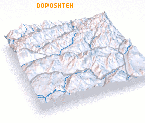 Places with similar names to Do Poshteh, Afghanistan ::
// Deh Poshteh (IR)
Disclaimer :: Information on this page comes without warranty of any kind |
||
|
Where is Do Poshteh? Elevation and coordinates ::
Latitude (lat): 34°18'0"N Longitude (lon): 68°3'0"E
Elevation (approx.): 2822m (map arrows pan, magnifying glasses zoom) |
||
|
Visiting Do Poshteh? Hotel/Accommodation ::
Book a hotel in Do Poshteh Travel Guide ::
Buy a travel guide for Afghanistan rental cars ::
car rental offers GPS waypoint ::
download a GPX waypoint (PoI) of Do Poshteh for your GPS receiver
|
||