|
search place name
|
||
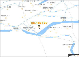
Qāẕī Kalay (Kandahār, Afghanistan)Qāẕī Kalay is a town in the Kandahār region of Afghanistan. An overview map of the region around Qāẕī Kalay is displayed below.
regional and 3d topo map of Qāẕī Kalay, Afghanistan ::
Qāẕī Kalay airports ::
The nearest airport is KDH - Kandahar, located 13.6 km north east of Qāẕī Kalay.
Other airports nearby include UET - Quetta (170.4 km south east), Nearby towns ::
Anbār Kalay (4.5km west) //
Sūkhteh-ye Moḩammad Ḩaqq Ākhvond (4.6km east) //
Kalāntar Kalay (6.0km north) //
Golestān Kalay (5.9km east) //
Mīrūgol Kalay (7.0km east) //
Deh Gholāmān (8.2km north west) //
Khvājeh ‘Alī Bābā (8.4km north west) //
Zarak Kalay (9.4km north east) //
Rūḩābād (8.7km north west) //
[all distances 'as the bird flies' and approximate] 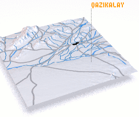 Places with similar names to Qāẕī Kalay, Afghanistan ::
// Keçikli (AZ)
// Qazqulu (AZ)
// Gaskil (US)
// Casa Cola (US)
// Kaschel (DE)
// Kühzagl (DE)
// Casa Cola (IT)
// Casaglia (IT)
// Case Galli (IT)
// Koziegłowy (PL)
Disclaimer :: Information on this page comes without warranty of any kind |
||
|
Where is Qāẕī Kalay? Elevation and coordinates ::
Latitude (lat): 31°24'26"N Longitude (lon): 65°45'48"E
Elevation (approx.): 983m (map arrows pan, magnifying glasses zoom) |
||
|
Visiting Qāẕī Kalay? Hotel/Accommodation ::
Book a hotel in Qāẕī Kalay Travel Guide ::
Buy a travel guide for Afghanistan rental cars ::
car rental offers GPS waypoint ::
download a GPX waypoint (PoI) of Qāẕī Kalay for your GPS receiver
|
||