|
search place name
|
||
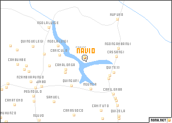
Navio (Malanje, Angola)Navio is a town in the Malanje region of Angola. An overview map of the region around Navio is displayed below.
regional and 3d topo map of Navio, Angola ::
Navio airports ::
The nearest airport is MEG - Malanje, located 29.4 km south west of Navio.
Other airports nearby include GXG - Negage (210.3 km north west), UGO - Uige (241.1 km north west), Nearby towns ::
Cange (2.2km north west) //
Camalonga (4.7km west) //
Força (5.0km south west) //
Quifucussa (5.9km south east) //
Ngunza (6.0km south) //
Camicula (5.9km west) //
Quinguri (6.1km south west) //
Gunza-Muanha (6.1km south east) //
Quitexi (6.4km east) //
Cassangi (6.6km east) //
Ngola Luigi (7.0km north west) //
Ngonga Mbandi (7.5km north east) //
Ngangassole I (7.9km west) //
Camilemba (9.1km south east) //
Cassembele (10.1km south east) //
Catobuela (10.6km south east) //
NʼGola Luige (10.9km north west) //
Samuel (11.0km south west) //
[all distances 'as the bird flies' and approximate] 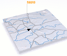 Places with similar names to Navio, Angola ::
Disclaimer :: Information on this page comes without warranty of any kind |
||
|
Where is Navio? Elevation and coordinates ::
Latitude (lat): 9°17'0"S Longitude (lon): 16°25'22"E
Elevation (approx.): 1114m (map arrows pan, magnifying glasses zoom) |
||
|
Visiting Navio? Hotel/Accommodation ::
Book a hotel in Navio Travel Guide ::
Buy a travel guide for Angola rental cars ::
car rental offers GPS waypoint ::
download a GPX waypoint (PoI) of Navio for your GPS receiver
|
||