|
search place name
|
||
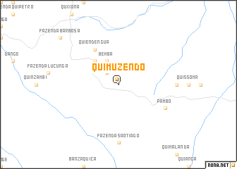
Quimuzendo (Uíge, Angola)Quimuzendo is a town in the Uíge region of Angola. An overview map of the region around Quimuzendo is displayed below.
regional and 3d topo map of Quimuzendo, Angola ::
Quimuzendo airports ::
The nearest airport is UGO - Uige, located 26.9 km south west of Quimuzendo.
Other airports nearby include GXG - Negage (44.4 km south), SSY - M'banza-congo Mbanza Congo (157.4 km north west), LAD - Luanda 4 De Fevereiro (265.6 km south west), Nearby towns ::
Quimussande e Caondo (2.6km north west) //
Quibianga (4.1km north west) //
Quicambunda (4.1km north west) //
Bemba (4.1km north west) //
Quilumbo (5.2km north west) //
Quiendêngua (6.7km north west) //
Pambo (8.2km south east) //
[all distances 'as the bird flies' and approximate]  Places with similar names to Quimuzendo, Angola ::
// Kimasandi (CD)
// Kimisundu (CD)
// Kamasundo (SL)
// Kamasundu (SL)
// Kamasundu (SL)
// Kamzende (NG)
// Camassandi (BR)
// Quimazundo (AO)
// Quimossundo (AO)
Disclaimer :: Information on this page comes without warranty of any kind |
||
|
Where is Quimuzendo? Elevation and coordinates ::
Latitude (lat): 7°23'0"S Longitude (lon): 15°8'0"E
Elevation (approx.): 1210m (map arrows pan, magnifying glasses zoom) |
||
|
Visiting Quimuzendo? Hotel/Accommodation ::
Book a hotel in Quimuzendo Travel Guide ::
Buy a travel guide for Angola rental cars ::
car rental offers GPS waypoint ::
download a GPX waypoint (PoI) of Quimuzendo for your GPS receiver
|
||