|
search place name
|
||
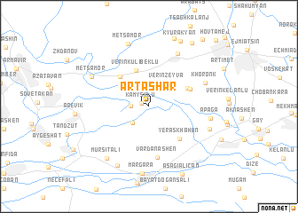
Artashar (Armavir, Armenia)Artashar is a town in the Armavir region of Armenia. An overview map of the region around Artashar is displayed below.
regional and 3d topo map of Artashar, Armenia ::
Artashar airports ::
The nearest airport is VAN - Van, located 196.3 km south of Artashar.
Nearby towns ::
Kamyshlu (0.8km north west) //
Zartʼonkʼ (1.7km west) //
Yeghegnut (2.6km south west) //
Taronik (3.1km north east) //
Verin Zeyva (3.3km north east) //
Verin-Kulibeklu (4.7km north) //
Aknalich (4.7km north west) //
Zeyva (4.3km north east) //
Arratashen (4.5km north east) //
Yeraskhahun (5.1km south east) //
Vardanashen (6.4km south) //
Arshaluys (7.2km north east) //
Khoronkʼ (6.1km north east) //
Apaga (6.1km east) //
Metsamor (6.7km north west) //
Karkhun (6.5km south east) //
Metsamor (8.2km north) //
Arazap (8.0km south) //
Margara (8.4km south) //
Mürşitali (7.7km south west) //
Kyurakyan (8.8km north) //
Ferik (8.9km north) //
Aşağıalican (9.1km south) //
Haytʼagh (9.0km north east) //
Samaghar (9.9km north east) //
Hovtamej (10.5km north east) //
[all distances 'as the bird flies' and approximate] 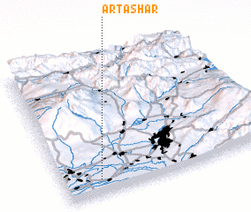 Places with similar names to Artashar, Armenia ::
Disclaimer :: Information on this page comes without warranty of any kind |
||
|
Where is Artashar? Elevation and coordinates ::
Latitude (lat): 40°6'33"N Longitude (lon): 44°10'52"E
Elevation (approx.): 847m (map arrows pan, magnifying glasses zoom) |
||
|
Visiting Artashar? Hotel/Accommodation ::
Book a hotel in Artashar Travel Guide ::
Buy a travel guide for Armenia rental cars ::
car rental offers GPS waypoint ::
download a GPX waypoint (PoI) of Artashar for your GPS receiver
|
||