|
search place name
|
||
Kzylkʼend (Gegharkʼunikʼ, Armenia)Kzylkʼend is a town in the Gegharkʼunikʼ region of Armenia. An overview map of the region around Kzylkʼend is displayed below.
regional and 3d topo map of Kzylkʼend, Armenia ::
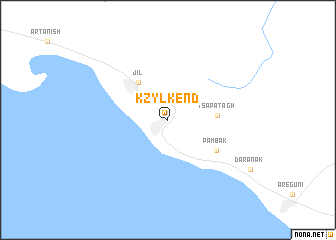
Nearby towns ::
Jil (4.9km north west) //
Tsapʼatʼagh (4.3km east) //
Pʼambak (5.3km south east) //
[all distances 'as the bird flies' and approximate] 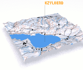 Places with similar names to Kzylkʼend, Armenia ::
// Qızılkǝnd (AZ)
// Goz el Kanado (TD)
// Guzalkent (UZ)
// Qezel Kand (IR)
// Qizil Kand (SY)
// Kızılkent (TR)
// G‘azalkent (UZ)
// Go‘zalkent (UZ)
// Qezel Kand (AF)
// Kyzylkend (AM)
Disclaimer :: Information on this page comes without warranty of any kind |
||
|
Where is Kzylkʼend? Elevation and coordinates ::
Latitude (lat): 40°25'0"N Longitude (lon): 45°29'0"E
Elevation (approx.): 2075m (map arrows pan, magnifying glasses zoom) |
||
|
Visiting Kzylkʼend? Hotel/Accommodation ::
Book a hotel in Kzylkʼend Travel Guide ::
Buy a travel guide for Armenia rental cars ::
car rental offers GPS waypoint ::
download a GPX waypoint (PoI) of Kzylkʼend for your GPS receiver
|
||