|
search place name
|
||
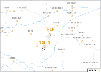
Tʼalin ((( Aparani Shrjan )), Armenia)Tʼalin is a town in the (( Aparani Shrjan )) region of Armenia. An overview map of the region around Tʼalin is displayed below.
regional and 3d topo map of Tʼalin, Armenia ::
Tʼalin airports ::
The nearest airport is VAN - Van, located 217.6 km south of Tʼalin.
Nearby towns ::
Akunk (4.2km north east) //
Talin (5.3km south) //
Kabakhtapa (5.2km south west) //
Nerkin Talin (6.0km south west) //
Katʼnaghbyur (5.1km east) //
Areg (5.5km west) //
Ashnak (6.9km south east) //
Mastara (7.5km north) //
Yekhnik (6.4km east) //
Karmrashen (8.2km north east) //
Vosketas (9.7km north east) //
[all distances 'as the bird flies' and approximate] 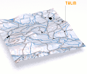 Places with similar names to Tʼalin, Armenia ::
Disclaimer :: Information on this page comes without warranty of any kind |
||
|
Where is Tʼalin? Elevation and coordinates ::
Latitude (lat): 40°22'56"N Longitude (lon): 43°52'43"E
Elevation (approx.): 1608m (map arrows pan, magnifying glasses zoom) |
||
|
Visiting Tʼalin? Hotel/Accommodation ::
Book a hotel in Tʼalin Travel Guide ::
Buy a travel guide for Armenia rental cars ::
car rental offers GPS waypoint ::
download a GPX waypoint (PoI) of Tʼalin for your GPS receiver
|
||