|
search place name
|
||
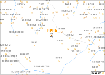
Avaş (Yardımlı, Azerbaijan)Avaş is a town in the Yardımlı region of Azerbaijan. An overview map of the region around Avaş is displayed below.
regional and 3d topo map of Avaş, Azerbaijan ::
Avaş airports ::
The nearest airport is TBZ - Tabriz Intl, located 183.6 km south west of Avaş.
Other airports nearby include RAS - Rasht (219.4 km south east), BAK - Baku Heydar Aliyev (241.0 km north east), Nearby towns ::
Pirembel (3.2km north east) //
Cirimbel (3.2km north east) //
Kurǝkçi (3.4km south east) //
‘Azīzlū (4.4km north west) //
Sheykh Chakhmāq Dāgh (4.6km north west) //
Tūlūn (4.5km west) //
Lankeh Daraq (4.5km west) //
Soleymālū (5.9km north west) //
Şǝfǝqli (4.9km east) //
Abdınlı (5.5km north east) //
Gyarsavan (6.0km south east) //
Deman (5.8km south west) //
Moghvān (7.4km north) //
Mashhadlū (7.6km north) //
Ānī Kandī (6.6km north west) //
Arvana (8.5km south) //
Qarah Bolāgh (8.5km north) //
Dağ Üzü (7.5km south east) //
Çay Üzü (7.2km east) //
Ānī-ye Soflá (8.3km north east) //
Ānī-ye Vosţá (8.3km north east) //
Ānī-ye ‘Olyā (9.4km north east) //
Peştǝsar (8.9km south east) //
Īn (10.4km south west) //
Ālāylah (10.5km north east) //
[all distances 'as the bird flies' and approximate]  Places with similar names to Avaş, Azerbaijan ::
Disclaimer :: Information on this page comes without warranty of any kind |
||
|
Where is Avaş? Elevation and coordinates ::
Latitude (lat): 38°54'11"N Longitude (lon): 48°5'56"E
Elevation (approx.): 1337m (map arrows pan, magnifying glasses zoom) |
||
|
Visiting Avaş? Hotel/Accommodation ::
Book a hotel in Avaş Travel Guide ::
Buy a travel guide for Azerbaijan rental cars ::
car rental offers GPS waypoint ::
download a GPX waypoint (PoI) of Avaş for your GPS receiver
|
||